|
"Turn
left at the next corner, dear"
[MAY
3, 2000] On most of our
vacations, we’ve packed the car full and driven to our
destination. I’m
usually in the driver’s seat, and my wife usually rides shotgun
as the navigator. On
most trips we’re fine, even jovial, comfortable and happy for
the first five or six hours of the trip, but then we begin to get
weary, hungry or just plain grumpy. And then the inevitable happens!
The driver (that’s me) asks in a grumpy tone for
directions from the navigator (my wife) for the next turn.
The navigator, also weary, hungry or just plain grumpy,
responds in kind. And
then it escalates as we find out in a panic that we’re not on
the right road at all. The
vacation, now only five hours old, ceases to be a vacation, and
our daughter in the back seat wishes she had stayed home.
|
|
My
wife is actually a very good navigator, and I am a pretty good
driver (if I might say so myself).
But invariably, a sign is missing, or we missed a sign, and
voila, we are tense, angry and holding each other accountable for
our current predicament. Twenty
years of vacations trips…. and then I discovered GPS.
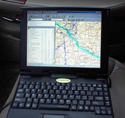
Using a laptop/notebook computer in the car, with special mapping
software, and a GPS (global positioning satellite) device, we
resolved our relational problem, got instructions for the best
roads, the shortest time and/or mileage, and even found an
excellent source for information along the route.
GPS computer navigation is great for vacation planning,
short trip navigation or planning for business trips.
[Information sent back from the GPS satellite is
then translated thought a computer program providing you with
accurate navigation.]
The special software is an intricately-detailed map of the entire
United States (and even shows parts of Canada) which has on it
every highway, every connector, every local road, and even gravel
and dirt roads. The
mapping software allows you to enter the place where you would
like to start your trip, and then also your destination. You
indicate to the program that you would like it to calculate a
route using specific or general road choices, a scenic route or,
if you are in a hurry, the quickest route, and the software charts
your upcoming journey on the map with a magenta line.

There is a treasure trove of information detailed on the map.
Included is information about motels and restaurants along
your route (even telephone numbers in case you want to call
ahead). You can zoom
in and zoom out in order to get a perfect perspective of the
details along the way, including names of forests, rivers, parks,
mountains, stores and waysides.
Perhaps the best feature of GPS computer navigation is that the
computer shows you your exact location marked on the map.
It appears as a green arrow pointing in the direction you
are traveling, and shows you where you have been.
You can see exactly which road you are on, where you are
heading and, in a navigation window, how soon you will arrive at
your next stop. It
even tells you your current elevation and your current speed.
But, best of all, the computer tells you in a plain voice
where and when to turn. I
call this divorce prevention!
In
order to use GPS to help plan and manage your trip, you will need
a notebook computer which has either a long-lasting battery or the
ability to plug into the cigarette lighter to provide lasting
power. You need a
CD-ROM drive in the notebook computer for the detailed mapping
data. And you will
need to purchase the GPS bundled hardware and software.
(To top of second
column)
|

There
are two packages on the market currently which I have either owned
or used. Rand McNally sells their bundled hardware/software package
called GPS Streetfinder 2000 for under $100.
It includes the GPS device which connects to the notebook
computer by an external serial port and rests on the dashboard of
the car. The mapping
software is intuitive, easy to use, and will adequately guide you
from point A to point B.
The bundle I am most familiar with is by a mapping company known
as Delorme. It is
called Street Atlas USA, and sells in most computer stores for
about $150. The
Earthmate GPS device (bright yellow) also sits on the dashboard of
the car to constantly get a glimpse of the invisible satellites in
the sky. It tracks your position (Delorme uses the satellite data to
triangulate and report your position on the screen, not to report
your position to the government).
The mapping software seems easy to use and best of all,
audibly gives directions right from your notebook speakers:
“Turn Southwest on I-497, still three minutes away.”

If you have a modem in your notebook system and an Internet
account, you can download the latest road conditions before you
begin your journey. The
software even makes automatic adjustments for road hazards and
road construction.
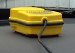
[Device for communicating with GPS satellite]
Our first experience with GPS cut hours off our drive time, showed
us which restaurants were coming up and helped us plot in advance
which motels we would choose. Even with GPS, though, we have made a few mistakes in
navigation. Road
signs are still imperfect, our ability to interpret them is
slightly flawed, and sometimes we still get just plain turned
around. But, the real
stress reliever in our travels with GPS is that now when we are on
the wrong road going the wrong way, we blame it on the computer!
[Jim
Youngquist, Lincoln
Daily News]
|