|
Storms renew flood concerns
Thunderstorms to roll in Friday
 Send a link to a friend
[June 26, 2008]
STATE COLLEGE, Pa. --
AccuWeather.com reports that severe storms erupting through Friday
will renew flooding concerns in the mid-Mississippi Valley while
sparking another tornado outbreak on the Plains.
|
|

According to the
AccuWeather.com Severe Weather Center, waves of energy are
riding the jet stream draped across the northern Plains and the
Midwest. The potent storms will feed on the abundant warm, moist air
flowing north out of the Gulf of Mexico, with daytime heating adding
instability to the atmosphere.
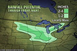
Over the Midwest, the strongest storms will produce heavy rain
that could lead to flash flooding, along with large hail and
damaging winds. In addition to the flooding rain, there will be an
increased potential for tornadoes across the region.
On Wednesday, the first of the new
wave of storm systems caused minor damage across the Midwest after
pummeling northern Missouri with heavy rain earlier in the day. Rain
totals over the 24-hour period ending at 1 a.m. CDT Thursday
include:
-
Ottumwa, Iowa: 3.33
inches
-
Columbus, Ohio: 3.03
inches
-
Fairfield, Iowa: 2.56
inches
-
Fort Madison, Iowa:
1.77 inches
-
Des Moines, Iowa: 1.75 inches
[to top of second column] |

The periods of heavy rain through Friday will exacerbate flooding on
the Mississippi River. Runoff from the storms Wednesday has raised
the forecast for the crest at St. Louis, which is expected to be
reached by Sunday afternoon, to 38.7 feet. Major flooding begins at
40.0 feet.
By Friday, the storm system will shift slowly to the East.
John Kocet, senior meteorologist, says the storm will persist
over the Mississippi Valley. "Storms that form over the northern
Plains tend to move southeastward, toward the hotter air that covers
the Midwest," he said. "In this case, that could result in heavy
downpours over the Mississippi Valley, which obviously is not good
news."
[Text from file received from
AccuWeather.com] |