|
 |
|
New tornado watch until 10 p.m.
(2:11 p.m.
Friday announcement)
 Send a link to a friend
[May 30, 2008]
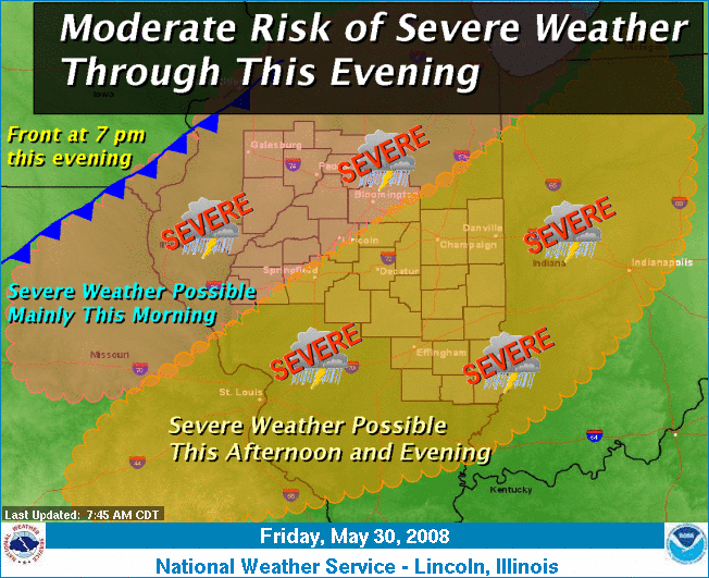
Severe storms were expected to
move as far east as northwestern Illinois early Friday morning but
were expected to weaken as they approached the Illinois River valley
by noon. The forecast indicated that a few severe storms might reach
as far east as Fulton, Knox and Stark counties during the morning,
with large hail and damaging winds the main hazards.
|
|
A cold front will push slowly southeast toward the area and finally
enter northwestern Illinois by 7 p.m. Friday. A second round of
severe storms is expected to develop by midafternoon across central
Illinois and progress toward southeast Illinois through the evening.
Damaging winds and large hail will be possible, along with a few
tornadoes.
Any lingering storms in southeastern Illinois after midnight
should remain below severe levels. Remain alert for updated
forecasts on this potential severe weather episode.
[Text from announcement received from
Terry Storer, Logan County Emergency Management Agency] |

|
 |
|
Tornado watch until 2 p.m.
(8:22 a.m.
Friday announcement)
Send a link to a friend
|
|
[May 30, 2008]
A tornado watch is in effect for
Logan County until 2 p.m. Friday. This may be the first of more
watches for the day. All agencies should prepare for severe
weather operations. Spotter activation may be required through 11
p.m.
[Text from announcement received from
Terry Storer, Logan County Emergency Management Agency]
 |

 |
|
|


|
Click the city for more
up-to-the-minute weather information.
 |
|
Back to top |
News |
Sports | Business |
Rural Review |
Teaching & Learning
|
Home and Family |
Tourism
| Obituaries
Community |
Perspectives
|
Law & Courts |
Leisure Time
|
Spiritual Life |
Health & Fitness |
Teen Scene
Calendar
|
Letters to the Editor
|


