| ||||||||||
| ||||||||||
___
On the Net:
Weather Underground: http://www.wunderground.com/
National Weather Service:
http://iwin.nws.noaa.gov/
Intellicast:
http://www.intellicast.com/
[Associated Press article from Weather Underground]
Copyright 2009 The Associated Press. All rights reserved. This material may not be published, broadcast, rewritten or redistributed.


Click the city for more up-to-the-minute weather information.
|
| Chicago, Ill. |
|
| Minneapolis, Minn. |
|
| Orlando, Fla. |
|
| Albuquerque, N.M. |
|
| Denver, Colo. |
|
| New York, N.Y. |
|
| San Francisco, Calif. |
|
| Dallas, Texas |
News | Sports | Business | Rural Review | Teaching & Learning | Home and Family | Tourism | Obituaries
Community |
Perspectives
|
Law & Courts |
Leisure Time
|
Spiritual Life |
Health & Fitness |
Teen Scene
Calendar
|
Letters to the Editor


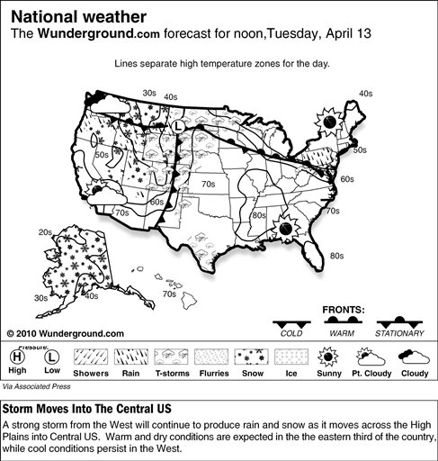
 he system was forecast to create a combination of fronts that would kick up stormy weather. One front would rapidly sweep eastward over the
central and northern Rockies, while the other would hover over the Northern Plains and stretch into the Great Lakes. The center of the low pressure system was expected to take a northerly track and move from the
central Rockies and into northern Plains toward central Canada. Thus, scattered snowfall would develop over the Rockies throughout the day, with snowfall accumulation between 2-5 inches in Colorado and Utah. Nearly an inch of rain was expected in the Dakotas, with more likely in areas of thunderstorm development. Forecasters said winds might gust up to 44 mph in the vicinity of the front. Some of these storms might turn severe as this system has a history of producing strong winds and hail.
he system was forecast to create a combination of fronts that would kick up stormy weather. One front would rapidly sweep eastward over the
central and northern Rockies, while the other would hover over the Northern Plains and stretch into the Great Lakes. The center of the low pressure system was expected to take a northerly track and move from the
central Rockies and into northern Plains toward central Canada. Thus, scattered snowfall would develop over the Rockies throughout the day, with snowfall accumulation between 2-5 inches in Colorado and Utah. Nearly an inch of rain was expected in the Dakotas, with more likely in areas of thunderstorm development. Forecasters said winds might gust up to 44 mph in the vicinity of the front. Some of these storms might turn severe as this system has a history of producing strong winds and hail.