| ||||||||||
| ||||||||||
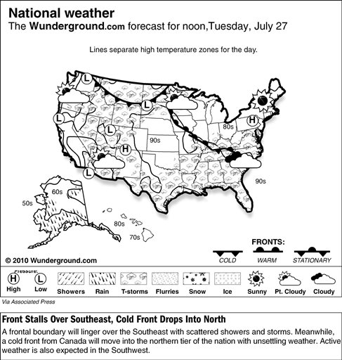
___
Online:
Weather Underground: http://www.wunderground.com/
National Weather Service:
http://iwin.nws.noaa.gov/
Intellicast:
http://www.intellicast.com/
[Associated Press article from Weather Underground]
Copyright 2009 The Associated Press. All rights reserved. This material may not be published, broadcast, rewritten or redistributed.


Click the city for more up-to-the-minute weather information.
|
| Chicago, Ill. |
|
| Minneapolis, Minn. |
|
| Orlando, Fla. |
|
| Albuquerque, N.M. |
|
| Denver, Colo. |
|
| New York, N.Y. |
|
| San Francisco, Calif. |
|
| Dallas, Texas |
News | Sports | Business | Rural Review | Teaching & Learning | Home and Family | Tourism | Obituaries
Community |
Perspectives
|
Law & Courts |
Leisure Time
|
Spiritual Life |
Health & Fitness |
Teen Scene
Calendar
|
Letters to the Editor