|


 Farms get individualized maps to avert emergencies
[April 25, 2011]
CHICAGO (AP)
--
|
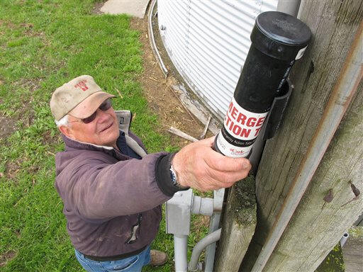
The sealed cylinders look fairly innocuous, but the contents inside are like gold for emergency responders -- detailed computer-generated maps of each farm, specifying precise locations for flammable chemicals and fuels, power turnoff switches, grain bins, water supplies and precious livestock. In fires, explosions, accidents and other farm emergencies, being able to quickly locate these items could prevent or reduce property damage, injuries and even deaths to farmers and rescuers. The vision can already be seen in east central Illinois, where a handful of these "emergency action tubes" have been distributed free to farmers. Several have attached them to the main power poles on their land, and sponsors are working to get dozens more farmers involved this year. The idea came naturally to Amy Rademaker, a farm safety specialist and educator at Carle Foundation Hospital in Urbana, who initiated the program. Her grandparents were farmers, and her parents still work the Moweaqua farm that has been in her family for more than 100 years. Farming is among the most dangerous industries, but Rademaker said tragedies can be prevented "if you can identify where things are going to go up in flames." Rademaker locates aerial images of each farm online, then takes printouts to farmers and works with them to identify structures, wells, power sources and potential hazards. She uses a GPS software program developed by Penn State University to produce the maps, and is working on getting local fire officials involved in the interviewing. The program operates with about $10,000 in funding, most of it from the hospital. Don and Lois Wood are among the projects' first participants. Their 40-acre farm just north of Champaign includes corn, soybeans and feeder cattle -- plus six barns, several storage sheds, crop bins and tanks for machinery fuel and heating oil. Their tube went up over a year ago, and "Thank the Lord," they've never had to use it, Lois Wood said. "I think it's a very good project," she said. "I hope it saves some lives." Michigan started a similar program about 15 years ago, with the state's Groundwater Stewardship Program providing free tubes and an online template for farmers to develop their own emergency plans and maps. More than 3,000 emergency plans have been developed, said Allen Krizek, an educational coordinator at Michigan State University Extension. And in Pennsylvania, Penn State educators worked with Future Farmers of America to develop a program for use in high schools, where students can make maps of individual farms. Rick Day, a Penn State geospacial technology specialist, said 32 school districts have been trained, but producing each map takes time and fewer than 50 have been created so far. Federal data show that more than 450 farmers or farm workers were killed in work-related accidents in 2008, and that each year, 113 children died from farm-related injuries. Thousands more people suffer nonfatal injuries, and machinery is among leading causes. Illinois averages about 32 farm-related deaths each year and close to 5,000 serious farm-related injuries, said Robert Aherin, agriculture safety program leader at the University of Illinois. A University of Illinois Extension report lists more than 800 farm fires in Illinois between 1990 and 2009, an admitted underestimate based solely on newspaper accounts. For emergency responders, knowing the exact layout of a farm can save minutes -- and perhaps property and lives. Rademaker plans to distribute copies of the maps to Illinois fire departments. So far there have been no emergencies on Illinois farms with emergency action tubes. But Rademaker said two local farmers whose barns burned to the ground within the past two years have since had maps drawn and will soon post their emergency action tubes. Peggy Romba, a manager and safety coordinator at the Illinois Farm Bureau, called the program "an excellent idea." "When you're dealing with emergency response to the farm, it's kind of a unique situation. It's more challenging than when you're in town, where you have fire hydrants" and buildings are more accessible, Romba said. Joe Burke, who grows 1,400 acres of corn and beans on two Thomasboro-area farmsteads, got an emergency map for one location last year and plans one for the second location this year. He said the dangers of farming are often on his mind, and that the emergency map program gives him peace of mind. "Anything we can do to give ourselves a leg up on safety," Burke said. |