| ||||||||||
| ||||||||||
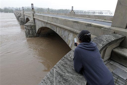
 And flooding it is, with record or near-record levels recorded along its path from New York state to Chesapeake Bay after a wet summer that included storms Irene and now Lee.
"The Susquehanna is one of the most flood-prone rivers in America," said Chris Duffy, a professor of civil and environmental engineering at Penn State University.
It's an especially shallow river, Duffy said, and that means big rainfalls can create floods rapidly. But another issue is what's underneath the water.
"Here, you encounter the bedrock pretty quickly," Duffy said, meaning that even floods won't quickly scour out deep spots. Upstream, the average river depth is only a few feet, and perhaps only 15 or 20 feet at the mouth.
In contrast, parts of New York's Hudson River are about 200 feet deep, and its shipping channel from New York City to Albany is maintained at a depth of about 32 feet, according to the U.S. Geological Survey.

The Susquehanna -- which derives its name from the Susquehannock tribe that once lived in the area -- is also one of the world's most ancient rivers, at about 200 million years old, Duffy said. It once flowed all the way to the ocean, but as sea levels rose its lower valley got submerged and became the Chesapeake.
The Susquehanna has flooded 14 times since 1810, according to the Susquehanna River Basin Commission -- an average of every 15 years. And most of the communities in the basin have residents in flood-prone areas- 1,160 out of 1,400.
The worst flood in modern times was in 1972, when the remnants of Hurricane Agnes dumped biblical rains. Seventy-two people died, and damage topped $2.8 billion -- about $14.3 billion in today's dollars, according to the river commission. So far, the current floods haven't been nearly as destructive.
Size is a factor in the river's propensity to overflow, too.
At about 450 miles long, the Susquehanna is the largest river in the eastern U.S. It drains a basin of more than 27,000 square miles containing more than 3.8 million people, according to Bucknell University, which estimates that floods cause an average of about $113 million in damage every year.
"It's just always been there," Duffy said of the flooding threat, so much so that many towns along its banks have been creating flood control structures, such as levees, for 100 or even 200 years. And even with the current crisis, Duffy said that some communities have prepared well for such events. "Wilkes-Barre has really taken care of business," he said. But not all the changes have helped mitigate flooding, he said. In the Colonial era, many tributaries had water-powered mills, and those may have helped control some of the water flowing into the river. "Yes, we have done some major manipulation of environments" along the river, Duffy said, but many wetlands are still intact along the tributaries. Weather experts note that the recent combination of Irene and Lee hitting the entire region with record rainfalls is bound to cause flooding.
[Associated
Press;
Copyright 2011 The Associated Press. All rights reserved. This material may not be published, broadcast, rewritten or redistributed.


News | Sports | Business | Rural Review | Teaching & Learning | Home and Family | Tourism | Obituaries
Community |
Perspectives
|
Law & Courts |
Leisure Time
|
Spiritual Life |
Health & Fitness |
Teen Scene
Calendar
|
Letters to the Editor