|
Rain and higher temps coming; potential for severe weather on Sunday
 Send a link to a friend
[April 13, 2012]
The National Weather
Service in Lincoln released the following weather outlook at 5:27
a.m. Friday for the counties of Cass, DeWitt, Fulton, Knox, Logan,
Marshall, Mason, Mclean, Menard, Morgan, Peoria, Sangamon, Schuyler,
Scott, Stark, Tazewell and Woodford in central Illinois.
|
 Friday and Friday night: Friday and Friday night:Widely scattered
thunderstorms will track across parts of central Illinois today. No
severe weather is expected.
Coverage of showers and thunderstorms will increase across the
area tonight as a warm front shifts north across the area. A few of
the storms late tonight may produce some small hail, but no
organized severe weather threat is anticipated.
Saturday through Thursday:
As a warm front lifts north across the area on Saturday,
scattered thunderstorms will be possible. There is a slight chance
for the storms to become severe, especially in the afternoon and
early evening. The primary threat would be from large hail and
damaging wind gusts.
A cold front is forecast to sweep across the area late Sunday
afternoon or evening, bringing another round of thunderstorms to the
area. The combination of instability and deep-layered shear will
provide a potential for strong to severe storms across the area
Sunday evening.
[to top of second column] |

Check later forecasts on this potential for
severe weather late Sunday or Sunday night.
___
Below: Graphical depiction of weather watch areas through the
weekend For more information and updates:
http://www.crh.noaa.gov/ilx/
[Text from National Weather Service,
Lincoln office] |
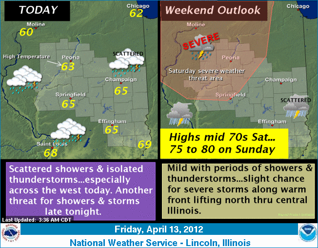
A weather disturbance will bring an increasing
threat for scattered showers and isolated thunderstorms to the area
today. Best coverage of rainfall appears to be across the west, with
another threat for showers and thunderstorms late tonight into
Saturday as a warm front lifts north across the region. Some of the
storms on Saturday could be severe, with large hail and damaging
winds the primary threat. An unsettled weather pattern will hold
across the area into Sunday with another threat for scattered
thunderstorms, especially late in the day and during the overnight
hours, as a cold front sweeps across the Midwest.
[Graphic copied from National Weather Service,
Lincoln office] |