 The following forecast is for the counties of Knox, Stark, Peoria,
Marshall, Woodford, Fulton, Tazewell, McLean, Schuyler, Mason,
Logan, DeWitt, Piatt, Champaign, Vermilion, Cass, Menard, Scott,
Morgan, Sangamon, Christian, Macon, Moultrie, Douglas, Coles, Edgar,
Shelby, Cumberland, Clark, Effingham, Jasper, Crawford, Clay,
Richland and Lawrence, including the cities of Galesburg, Peoria,
Bloomington, Normal, Havana, Lincoln, Champaign, Urbana, Danville,
Jacksonville, Springfield, Taylorville, Decatur, Charleston,
Mattoon, Shelbyville, Effingham, Flora and Lawrenceville: The following forecast is for the counties of Knox, Stark, Peoria,
Marshall, Woodford, Fulton, Tazewell, McLean, Schuyler, Mason,
Logan, DeWitt, Piatt, Champaign, Vermilion, Cass, Menard, Scott,
Morgan, Sangamon, Christian, Macon, Moultrie, Douglas, Coles, Edgar,
Shelby, Cumberland, Clark, Effingham, Jasper, Crawford, Clay,
Richland and Lawrence, including the cities of Galesburg, Peoria,
Bloomington, Normal, Havana, Lincoln, Champaign, Urbana, Danville,
Jacksonville, Springfield, Taylorville, Decatur, Charleston,
Mattoon, Shelbyville, Effingham, Flora and Lawrenceville:

Hurricane Isaac, which came ashore in southeast Louisiana early this
morning, is expected to track northwest through the lower
Mississippi Valley through late Thursday before heading on a more
northerly course on Friday. Rain will gradually spread north into
the area on Friday and continue through much of the weekend. By
Saturday the storm will begin to move northeast. Current projections
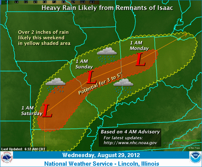
from the National Hurricane Center indicate the remnants of Isaac
will be located in southwest Missouri very early on Saturday, with
the weakening surface low moving roughly along a
Jacksonville-to-Danville line on Sunday.
Based on the current track of this system, heavy rains will
likely occur over parts of central and southeast Illinois during the
holiday weekend. Current rainfall forecasts indicate the potential
for 3 to 5 inches of rain along the track of the low through Monday,
with locally higher amounts possible. In addition to the heavy rain
threat, gusty winds may accompany some of the heavier showers and
thunderstorms as the system approaches on Saturday night.
[to top of second column] |

A large portion of the Midwest, from southern Missouri into central
Indiana, will have the potential for heavy rain. However, any
deviation in the forecast track will produce a significant
adjustment in the axis of heavy rain across the region.
The weather service says to be sure to monitor later forecasts if
you have any outdoor plans for the upcoming holiday weekend or if
you will be traveling across the Midwest.
___
Graphical depiction:
http://www.crh.noaa.gov/wxstory.php?site=ilx
or see below.
___
For more information and updates:
http://www.crh.noaa.gov/ilx/
[Text from National Weather Service,
Lincoln office]
 |