|
Wet day to deteriorate rapidly: high winds, snow, falling temps
 Send a link to a friend
[December 20, 2012]
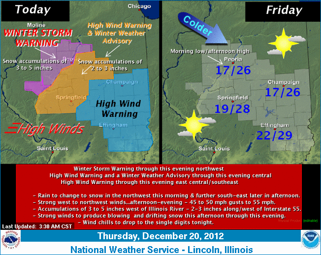
A high wind warning and winter weather
advisory released at 6:10 a.m. Thursday are in effect from noon to
midnight. This hazardous weather outlook is for portions of central
Illinois, specifically the counties of Cass, Logan, Mason, McLean,
Menard, Morgan, Sangamon, Scott and Tazewell.
|
 Thursday and Thursday night Thursday and Thursday nightNo problems for the morning
drive to work or school, but conditions are expected to deteriorate
rapidly this afternoon as strong winds and snow move in, along with
falling temperatures.
Rain will change over to snow during the afternoon, with
accumulations of 2 to 3 inches possible by Thursday evening and
higher totals just to our west and north. Strong west to northwest
winds, gusting as high as 55 mph at times, are expected to develop
over the area by late morning into the early evening hours. These
strong winds will produce blowing snow and may cause some tree
damage and potential power outages. Wind chills will lower to
between 3 below and 5 above zero late tonight into Friday morning.

Friday through Wednesday
There will be another chance for snow on Christmas Day and
Wednesday.
[to top of second column] |
 Spotter information statement
Spotter activation is not anticipated tonight. However, any
reports of snow accumulation and wind gusts greater than 40 mph
would be most appreciated.
___
Graphical depiction:
http://www.crh.noaa.gov/wxstory.php?site=ilx
(or see below)
For more information and updates:
http://www.crh.noaa.gov/ilx/
[Text from National Weather Service,
Lincoln office]
 |
|
Rain will change over to snow across the west and
northwest part of the state later Thursday morning as the strong
storm tracks across central Illinois.
The changeover to snow farther
east will occur Thursday afternoon as the center of the low shifts
to near Chicago. Once that happens, winds will increase from a west
to northwest direction with speeds of 35 to 45 mph and occasional
gusts around 55 mph. This will cause considerable blowing and
drifting snow in areas along and west of the Illinois River Thursday
afternoon, with near blizzard conditions in a few locations.
Farther east, the transition to
snow will occur from west to east Thursday afternoon and evening.
Areas roughly along and west of a Bloomington-to-Springfield line
may see 2 to 3 inches late this afternoon into this evening, with
the blowing and drifting concern setting in for the drive home from
work or school.
Over east-central and southeast
Illinois, snow accumulations for the most part will be an inch or
less, but the strong winds will cause whatever snow that does fall
to blow around and cause slippery roads Thursday evening. |