 The NWS message said that low pressure will track out of New Mexico
and into the central Plains Thursday and into the western Great
Lakes by sunset Friday. The NWS message said that low pressure will track out of New Mexico
and into the central Plains Thursday and into the western Great
Lakes by sunset Friday.
Snow will develop in extreme western Illinois by midday Thursday
and spread northeast over central and east-central Illinois during
the afternoon and evening on Thursday. Snow will gradually become
mixed with sleet or freezing rain by Thursday afternoon over
southeast Illinois and over central Illinois during the night
Thursday. Snowfall amounts of 4 to 6 inches will be possible west of
Interstate 55, with the heaviest amounts over Knox, Fulton and
Schuyler counties.
East winds will increase Thursday afternoon and will be gusting
up to 30 mph. This will produce some blowing and drifting of the
snow Thursday afternoon into Thursday evening, especially northwest
of the Illinois River.

A winter storm watch remains in effect from Thursday afternoon
through late Thursday night for the counties of Knox, Stark, Peoria,
Marshall, Woodford, Fulton, Tazewell, Schuyler, Mason, Logan, Cass,
Menard, Scott, Morgan, Sangamon and Christian, including the cities
of Galesburg, Peoria, Havana, Lincoln, Jacksonville, Springfield and
Taylorville.
Timing: Snow will develop over parts of west-central Illinois
by early Thursday afternoon and continue through Thursday evening.
Accumulations: 4 to 6 inches of snow, with heaviest amounts
northwest of the Illinois River.
Wind: East winds will increase to between 15 and 20 mph, with
a few gusts reaching 30 mph, which will cause some blowing and
drifting of snow Thursday afternoon into Thursday evening.
[to top of second column] |

Impacts: Conditions will deteriorate rapidly once the snow
begins. Travel will become hazardous due to poor visibility and
roads quickly becoming snow-covered and icy. The potential for some
sleet or freezing rain will make driving conditions even more
hazardous, especially late Thursday afternoon through Thursday
night.
Precautionary, preparedness actions: A winter storm watch
means there is a potential for significant snow, sleet or ice
accumulations that may affect travel. Continue to monitor the latest
forecasts.
___
Source:
http://www.crh.noaa.gov/news/display_cmsstory.
php?wfo=ilx&storyid=92684&source=0
___
Keep watch at NWS, Central Illinois:
http://www.crh.noaa.gov/ilx/
Graphical depiction:
http://www.crh.noaa.gov/wxstory.php?site=ilx
(Or see below for graphic posted by NWS on
Wednesday.)
[Text from National Weather Service,
Lincoln office]
 |
|
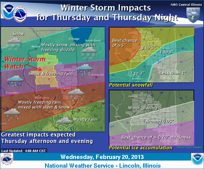
A winter storm continues to take aim on central
and southeast Illinois for Thursday and Thursday night.
Precipitation is expected to begin to spread in from the southwest
late Thursday morning and continue through the evening hours before
diminishing after midnight. While this will start as snow, it will
begin to mix with or change to sleet and freezing rain, especially
after late afternoon. The greatest snow accumulations are expected
along and northwest of the Illinois River, while locations along and
south of Interstate 70 have the greatest potential for significant
ice accumulation.
There is still some uncertainty
in the details of this system, which would affect where the heavier
snow and ice amounts occur, so continue to monitor the latest
forecasts for updates on this system. A winter storm watch has been
issued for a portion of central Illinois and is in effect for
Thursday afternoon through Thursday night. |