 The NWS released the following weather statement at 4:07 a.m.
Saturday for the counties of Knox, Stark, Peoria, Marshall,
Woodford, Fulton, Tazewell, McLean, Schuyler, Mason, Logan, DeWitt,
Piatt, Champaign, Vermilion, Cass, Menard, Scott, Morgan, Sangamon,
Christian, Macon, Moultrie, Douglas, Coles, Edgar, Shelby,
Cumberland, Clark, Effingham, Jasper, Crawford, Clay, Richland and
Lawrence, including the cities of Galesburg, Peoria, Bloomington,
Normal, Havana, Lincoln, Champaign, Urbana, Danville, Jacksonville,
Springfield, Taylorville, Decatur, Charleston, Mattoon, Shelbyville,
Effingham, Flora and Lawrenceville. The NWS released the following weather statement at 4:07 a.m.
Saturday for the counties of Knox, Stark, Peoria, Marshall,
Woodford, Fulton, Tazewell, McLean, Schuyler, Mason, Logan, DeWitt,
Piatt, Champaign, Vermilion, Cass, Menard, Scott, Morgan, Sangamon,
Christian, Macon, Moultrie, Douglas, Coles, Edgar, Shelby,
Cumberland, Clark, Effingham, Jasper, Crawford, Clay, Richland and
Lawrence, including the cities of Galesburg, Peoria, Bloomington,
Normal, Havana, Lincoln, Champaign, Urbana, Danville, Jacksonville,
Springfield, Taylorville, Decatur, Charleston, Mattoon, Shelbyville,
Effingham, Flora and Lawrenceville.

A mix of precipitation is
expected Saturday night into Sunday morning across central Illinois
as low pressure moves northeast along the Ohio River. Much colder
air will usher into central Illinois by later Saturday night. Any
rain Saturday evening along and northwest of the Illinois River will
quickly change to snow and sleet and continue overnight, with 1 to 2
inches of mainly snow accumulation expected. Rain will change to
freezing rain and sleet in the evening for areas between Interstate
55 and a line from Taylorville to Champaign. The precipitation
should change to snow from west to east by late Saturday night as it
diminishes from west to east.
[to top of second column] |

A chance of mixed precipitation will linger into Sunday morning,
especially along and east of Interstate 57. Areas toward
Lawrenceville will likely remain rain until later on Sunday, when
snow develops. Additional wintry accumulation on Sunday should be
light.
Untreated roads will likely become slippery Saturday night into
Sunday morning.
___
Graphical depiction:
http://www.crh.noaa.gov/wxstory.php?site=ilx
(or see below)
For later forecasts and updates on this winter weather situation,
check
http://www.crh.noaa.gov/ilx/.
[Text from National Weather Service,
Lincoln office]
 |
|
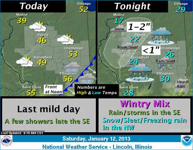
One more mild January day is on tap Saturday as
high clouds gradually thicken and a cold front passes from northwest
to southeast. A few showers may even develop toward Lawrenceville
late Saturday afternoon as low pressure approaches from eastern
Texas along that front. Highs will range from the mid-40s to upper
50s.
Saturday evening, rain will spread northeast to near Interstate 55,
with snow and sleet developing northwest of there. As colder air
flows into the area from the northwest, freezing rain and sleet may
become the primary precipitation between the Illinois River and as
far south as I-72. A few thunderstorms may even develop Saturday
evening south of I-70, where heavy rain of 1-2 inches is likely.
Snow
amounts by Sunday morning along and northwest of the Illinois River
may reach up to 1-2 inches, with lower amounts toward I-55 and
farther southeast. Light ice accumulations, less than a tenth of an
inch, are also possible southeast of the Illinois River to I-70
after midnight into Sunday morning.
The sharply colder temperatures
by Sunday morning could create slippery conditions on untreated
roadways after the mixed precipitation. |