|
 An area of low pressure will strengthen over
southern Missouri on Saturday night, then track east along the Ohio
River on Sunday. This will produce snow, some of it heavy at times,
starting late Saturday night and continuing into Sunday night. An area of low pressure will strengthen over
southern Missouri on Saturday night, then track east along the Ohio
River on Sunday. This will produce snow, some of it heavy at times,
starting late Saturday night and continuing into Sunday night.
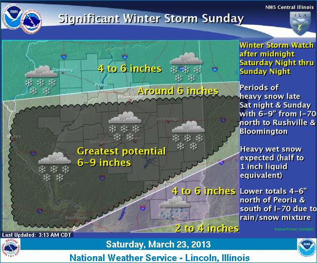
Current indications suggest the potential for 6
to 9 inches of heavy, wet snow, especially along and south of a line
from El Paso to Fairview and north of a line from Effingham to
Marshall. The heaviest snow region will be centered on a
Taylorville-to-Chrisman line.
A winter storm watch remains in effect from late Saturday night
through late Sunday night for the counties of Knox, Stark, Peoria,
Fulton, Tazewell, Schuyler, Mason, Logan, Cass, Menard, Scott,
Morgan, Sangamon, Christian, Macon, Moultrie, Shelby, Effingham and
Clay, including the cities of Galesburg, Peoria, Havana, Lincoln,
Jacksonville, Springfield, Taylorville, Decatur, Shelbyville,
Effingham and Flora.

Timing: Snow will develop across the area by midnight
Saturday and continue Sunday into Sunday night.
Accumulations: Snow will range from 6 to 9 inches over
central Illinois, with 4 to 6 inches north of an El Paso-to-Fairview
line and south of an Effingham-to-Marshall line.
[to top of second column] |

Wind: Northeast winds of 15 to 25 mph, with gusts
occasionally as high as 30 mph, will shift more to a north to
northwest direction Sunday night.
Impacts: Snow-covered and hazardous roadways. Temperatures
Sunday will be in the low to mid-30s but fall back into the middle
20s Sunday night, so any wet or slush-covered roads will refreeze.
Precautionary, preparedness actions: A winter storm watch
means there is a potential for significant snow, sleet or ice
accumulations that may affect travel. Continue to monitor the latest
forecasts.
___
See warned areas affected:
http://www.crh.noaa.gov/ilx/
For details on areas affected,
click here.
Graphical depiction:
http://www.crh.noaa.gov/wxstory.php?site=ilx
(Or see March 23 weather graphic below.)
[Text from National Weather Service,
Lincoln office]
 |
|
A significant late-season winter storm is expected to affect central
and southeast Illinois by Sunday, and a winter storm watch has been
issued for after midnight Saturday through Sunday night. Snow is
expected to spread northeast into the area by overnight Saturday and
continue through Sunday night before diminishing Monday morning.
Many locations have the
potential for 6-9 inches of snow. However, areas south of Interstate
70 may see some rain mix in at times into Sunday morning, which
would lower the snow totals to 4-6 inches, and also in areas north
of Peoria, with 4-6 inches expected.
While northeast winds
on Sunday will range from 20 to 25 mph, the heavy, wet nature of the
snow should prevent any significant blowing and drifting snow,
although visibility will be very low in the heavier snow bands.
Anyone traveling across
Illinois or adjacent states overnight Saturday through Sunday night,
especially south of I-80 to along I-70, should monitor the latest
forecasts. |