|
 The nation's weather The nation's weather
 Send a link to a friend
[May 02, 2009]
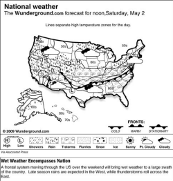
(AP) Severe weather will persist over the East on Saturday as two frontal systems sweep through the region while a ridge of high pressure will pull cool air over the Northern Plains and Great Lakes region.
The front in the South is expected to bring moderate to heavy rainfall, strong winds, hail and thunderstorms. This system has a history of producing severe weather with tornadoes.
|
|
 In the Mid-Mississippi Valley, flooding will remain a threat as this is a slow moving system. In the Mid-Mississippi Valley, flooding will remain a threat as this is a slow moving system.
In the West, a low pressure system will continue spinning over the Pacific Ocean, pushing moist conditions onshore. This will bring cool and cloudy conditions to the West Coast and is expected to trigger scattered rain over northern California and the Pacific Northwest.
Temperatures in the Lower 48 states Friday ranged from a low of 7 degrees at Yellowstone, Wyo., to a high of 102 degrees at Pecos, Texas.
---
On the Net:
Weather Underground: http://www.wunderground.com/
National Weather Service:
http://iwin.nws.noaa.gov/
Intellicast:
http://www.intellicast.com/
[Associated
Press article
from Weather
Underground]
Copyright 2009 The Associated Press. All rights reserved. This
material may not be published, broadcast, rewritten or
redistributed.
|


 |