| ||||||||||
| ||||||||||
___
On the Net:
Weather Underground: http://www.wunderground.com/
National Weather Service:
http://iwin.nws.noaa.gov/
Intellicast:
http://www.intellicast.com/
[Associated Press article from Weather Underground]
Copyright 2009 The Associated Press. All rights reserved. This material may not be published, broadcast, rewritten or redistributed.


Click the city for more up-to-the-minute weather information.
|
| Chicago, Ill. |
|
| Minneapolis, Minn. |
|
| Orlando, Fla. |
|
| Albuquerque, N.M. |
|
| Denver, Colo. |
|
| New York, N.Y. |
|
| San Francisco, Calif. |
|
| Dallas, Texas |
News | Sports | Business | Rural Review | Teaching & Learning | Home and Family | Tourism | Obituaries
Community |
Perspectives
|
Law & Courts |
Leisure Time
|
Spiritual Life |
Health & Fitness |
Teen Scene
Calendar
|
Letters to the Editor


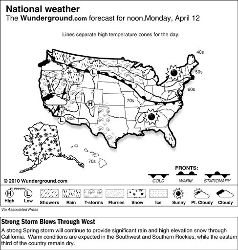
 Increasing instability across California would translate into scattered rain showers and thunderstorms through the afternoon. As this system pushed inland, plenty of Pacific moisture and energy would lift over the mountains and trigger high-elevation snow showers with gusty winds. Winter storm warnings and advisories would remain in effect for the Sierras in anticipation of more snow. By the end of the day, moisture and associated frontal systems would kick up additional precipitation across the Intermountain West and the northern Midwest.