|
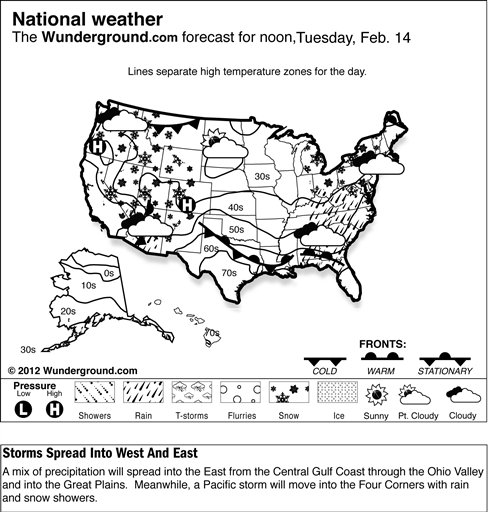
 The trough will support a low and associated warm front moving eastward into the
southern Plains. As the system progresses, rain showers with periods of heavy rain and isolated thunderstorms will spread from parts of central
and eastern Texas into western Louisiana, mixed precipitation will develop in parts of Oklahoma and Arkansas, and snow will blanket parts of the
central Plains, Mid-Mississippi Valley and parts of the western Ohio Valley. Areas from eastern Texas through Arkansas should expect the heaviest precipitation totals. Heightened winter weather conditions will allow
winter weather advisories and a few winter storm warnings to remain in effect through the day. Elsewhere east of the Continental Divide, lake-effect snow showers will continue along parts of the
lower Great Lakes snow belt. The trough will support a low and associated warm front moving eastward into the
southern Plains. As the system progresses, rain showers with periods of heavy rain and isolated thunderstorms will spread from parts of central
and eastern Texas into western Louisiana, mixed precipitation will develop in parts of Oklahoma and Arkansas, and snow will blanket parts of the
central Plains, Mid-Mississippi Valley and parts of the western Ohio Valley. Areas from eastern Texas through Arkansas should expect the heaviest precipitation totals. Heightened winter weather conditions will allow
winter weather advisories and a few winter storm warnings to remain in effect through the day. Elsewhere east of the Continental Divide, lake-effect snow showers will continue along parts of the
lower Great Lakes snow belt.
In the West, a Pacific cold front pushing across the Pacific Northwest will drop southward across northern California, bringing coastal and valley rain and significant snowfall to the Sierra Nevadas.
Temperatures in the Lower 48 states Sunday have ranged from a morning low of
minus 20 degrees at Mount Washington, N.H., to a high of 72 degrees at Thermal, Calif.
|