|
 Arthur,
no longer a hurricane, pelts Maritime Canada Arthur,
no longer a hurricane, pelts Maritime Canada
 Send a link to a friend
[July 07, 2014]
By David Bailey
(Reuters) - Arthur weakened from hurricane
force on Saturday and pelted parts of Canada's eastern coast with heavy
rain and strong winds, leaving 250,000 homes and businesses without
power, as the storm swept away from New England.
|
|
 Arthur weakened to a tropical storm on Saturday morning after
having reached landfall on North Carolina's Outer Banks late on
Thursday as a Category 2 hurricane, snarling plans for tourists at
the start of the Fourth of July holiday weekend. Arthur weakened to a tropical storm on Saturday morning after
having reached landfall on North Carolina's Outer Banks late on
Thursday as a Category 2 hurricane, snarling plans for tourists at
the start of the Fourth of July holiday weekend.
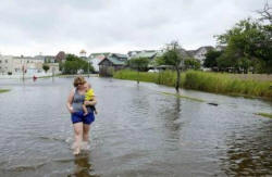
North Carolina reported only slight damage from the hurricane, which
quickly traveled northeast.
Arthur, now a post-tropical storm, was centered about 90 miles (146
km) southwest of the Magdalen Islands on Saturday night after making
a second landfall in Canada on Saturday afternoon.
The still intense storm, with maximum sustained winds of about 60
miles per hour (90 km per hour), was expected to head northeast
across the Gulf of St. Lawrence and Newfoundland on Sunday before
exiting into the North Atlantic, Environment Canada's Canadian
Hurricane Centre said.

"Basically, it lost its tropical characteristics and has become more
a wintertime-type low," said Daniel Brown, a senior hurricane
specialist at the U.S. National Hurricane Center.
More than 122,000 customers in Nova Scotia and 140,000 in New
Brunswick were left without power on Saturday night due to strong
winds and heavy rain that were expected to continue over parts of
southeastern Canada into Sunday.
Arthur was the first hurricane to hit the United States since
Superstorm Sandy devastated New York and New Jersey in October 2012,
causing an estimated $70 billion in damage.
In Maine, some communities reported power outages and trees down,
but there were no injuries from Arthur, according to the National
Weather Service, which received unofficial reports of more than 6
inches of rain (15 cm) in the eastern tip of the state.
"It's going to continue to wind down as we go through the afternoon
hours," said Dustin Jordan, a weather service meteorologist in
Caribou, Maine.
[to top of second column] |

Arthur hit landfall with top sustained winds of 100 mph (160 kph),
earning a Category 2 status on the five-step Saffir-Simpson scale.
It weakened to a Category 1 as it moved northeast into colder waters
of the Atlantic Ocean with 90-mph (145-kph) top sustained winds.
The storm lashed the popular Massachusetts resort island of
Nantucket with powerful winds and heavy rain on Friday night.
In North Carolina, Arthur cut power to almost 20,000 homes and
businesses, downed trees and cut off barrier islands from the
mainland after making landfall on the state's Outer Banks.
Power was restored to the tourist haven of Ocracoke Island late on
Saturday.
A highway connecting Hatteras Island to the mainland, which had
been blocked, was back in use and Hatteras and Ocracoke islands were
re-opened to the public.
(Reporting by David Bailey in Minneapolis; Additional reporting by
Eric Martyn in Bedford, Nova Scotia, and Gene Cherry in North
Carolina; Editing by Alex Dobuzinskis, Stephen Powell, Leslie Adler
and Lisa Shumaker & Kim Coghill)
[© 2014 Thomson Reuters. All rights
reserved.] Copyright 2014 Reuters. All rights reserved. This material may not be published,
broadcast, rewritten or redistributed.
 |