|
Winter Outlook favors warmer
temperatures for much of U.S.
Wet southern states to contrast drought in
West
 Send a link to a friend
 [October 24, 2018] [October 24, 2018]
LINCOLN
A mild winter could be in store for much of the United States this
winter according to NOAA’s Climate Prediction Center. In the U.S.
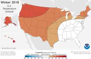
Winter Outlook for December through February, above-average
temperatures are most likely across the northern and western U.S.,
Alaska and Hawaii.
Additionally, El Nino has a 70 to 75 percent chance of developing.
“We expect El Nino to be in place in late fall to early winter,”
said Mike Halpert, deputy director of NOAA’s Climate Prediction
Center. “Although a weak El Nino is expected, it may still influence
the winter season by bringing wetter conditions across the southern
United States, and warmer, drier conditions to parts of the North.”
El Nino is an ocean-atmosphere climate interaction that is linked to
periodic warming in sea surface temperatures in the central and
eastern equatorial Pacific. During the winter, typical El Nino
conditions in the U.S. can include wetter-than-average precipitation
in the South and drier conditions in parts of the North.

Other climate patterns that can affect winter weather are
challenging to predict on a seasonal time scale. The Arctic
Oscillation influences the number of arctic air masses that
penetrate into the South and could result in below-average
temperatures in the eastern part of the U.S. The Madden-Julian
Oscillation can contribute to heavy precipitation events along the
West Coast – which could play a large role in shaping the upcoming
winter, especially if El Nino is weak, as forecasters predict.
The 2018 U.S. Winter Outlook (December through February):
Temperature
Warmer-than-normal conditions are anticipated across much of the
northern and western U.S., with the greatest likelihood in Alaska
and from the Pacific Northwest to the Northern Plains.
The Southeast, Tennessee Valley, Ohio Valley and Mid-Atlantic all
have equal chances for below-, near- or above-average temperatures.
No part of the U.S. is favored to have below-average temperatures.
[to top of second column] |


Precipitation
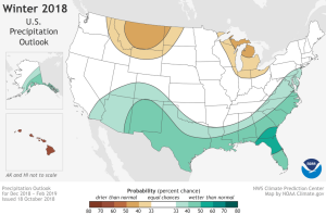
Wetter-than-average conditions are favored across the southern tier
of the U.S., and up into the Mid-Atlantic. Northern Florida and
southern Georgia have the greatest odds for above-average
precipitation this winter.
Drier-than-average conditions are most likely in parts of the
northern Rockies and Northern Plains, as well as in the Great Lakes
and northern Ohio Valley.

Drought
Drought conditions are likely to persist across portions of the
Southwest, Southern California, the central Great Basin, central
Rockies, Northern Plains and portions of the interior Pacific
Northwest.
Drought conditions are anticipated to improve in areas throughout
Arizona and New Mexico, southern sections of Utah and Colorado, the
coastal Pacific Northwest and the Central Plains.
NOAA’s seasonal outlooks give the likelihood that temperatures and
precipitation will be above-, near- or below-average, and how
drought conditions are expected to change, but the outlook does not
project seasonal snowfall accumulations. Snow forecasts are
generally not predictable more than a week in advance. Even during a
warmer-than-average winter, periods of cold temperatures and
snowfall are still likely to occur.
NOAA’s Climate Prediction Center updates the three-month outlook
each month. The next update will be available on Nov. 15.
NOAA produces seasonal outlooks to help communities prepare for what
is likely to come in the next few months and minimize weather's
impacts on lives and livelihoods. Empowering people with actionable
forecasts and winter weather tips is key to NOAA’s effort to build a
Weather-Ready Nation.
[National Oceanic and Atmospheric
Administration (NOAA)]
 |