|
Exclusive: More than 1 million acres of
U.S. cropland ravaged by floods
 Send a link to a friend
 [March 30, 2019]
By P.J. Huffstutter and Humeyra Pamuk [March 30, 2019]
By P.J. Huffstutter and Humeyra Pamuk
CHICAGO/COLUMBUS, Neb. (Reuters) - At least
1 million acres (405,000 hectares) of U.S. farmland were flooded after
the "bomb cyclone" storm left wide swaths of nine major grain producing
states under water this month, satellite data analyzed by Gro
Intelligence for Reuters showed.
Farms from the Dakotas to Missouri and beyond have been under water for
a week or more, possibly impeding planting and damaging soil. The
floods, which came just weeks before planting season starts in the
Midwest, will likely reduce corn, wheat and soy production this year.
"There's thousands of acres that won't be able to be planted," Ryan
Sonderup, 36, of Fullerton, Nebraska, who has been farming for 18 years,
said in a recent interview.
"If we had straight sunshine now until May and June, maybe it can be
done, but I don't see how that soil gets back with expected rainfall."

Spring floods could yet impact an even bigger area of cropland. The U.S.
government's National Oceanic and Atmospheric Administration has warned
of what could be an "unprecedented flood season" as it forecasts heavy
spring rains. Rivers may swell further as a deep snow pack in northern
growing areas melts.
The bomb cyclone of mid-March was the latest blow to farmers suffering
from years of falling income and lower exports because of the U.S.-China
trade war.
Fields are strewn with everything from silt and sand to tires and some
may not even be farmed this year. The water has also destroyed billions
of dollars of old crops that were in storage, as well as damaging roads
and railways.
Justin Mensik, a fifth-generation farmer of corn and soybeans in Morse
Bluff, Nebraska, said rebuilding roads was the first priority. Then
farmers would need to bring in fertilizer trucks and then test soil
before seeding, Mensik said.
The flood "left a lot of silt and sand and mud in our fields, now we're
not too sure if we're going to be able to get a good crop this year with
all the new mud and junk that's just laying here," Mensik told Reuters.
CORN CONCERN
For farmers, "the biggest concern right now is corn planting," said
Aaron Saeugling, an agriculture expert at Iowa State University who does
outreach with farmers. "There is just not going to be enough time to
move a lot of that debris."
To be fully covered by crop insurance, Iowa farmers must plant corn by
May 31 and soybeans by June 15, as yields decline dramatically when
planted any later. Deadlines vary state by state. The insurance helps
ensure a minimum price farmers will receive when they book sales for
their crops.

Nearly 1.1 million acres of cropland and more than 84,000 acres of
pastureland in the U.S. Midwest had flood water on it for at least seven
days between March 8 and March 21, according to a preliminary analysis
of government and satellite data by New-York based Gro Intelligence at
the request of Reuters. The extent of the flooding had previously not
been made public.
[to top of second column]
|
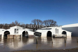
Paddocks at Washington County Fairgrounds are shown underwater due
to flooding in Arlington, Nebraska, U.S., March 21, 2019. REUTERS/Humeyra
Pamuk -File Photo

The flooded acreage represents less than 1 percent of U.S. land used
to grow corn, soybeans, wheat, rice, cotton, sorghum and barley. In
2018, some 240 million total acres of these crops were planted in
the United States, USDA data shows.
Iowa, the top U.S. corn and No. 2 soy producing state, had the most
water, covering 474,271 acres, followed by Missouri with 203,188
acres, according to Gro Intelligence. That was in line with
estimates given to Reuters this week by government officials in Iowa
and Missouri.
Gro Intelligence used satellite data from the National Aeronautics
and Space Administration’s (NASA) Near Real-Time Global Flood
Mapping product, to calculate the approximate extent and intensity
of flooding.
Gro Intelligence then identified how much of this area was either
cropland or pastureland, according to data from the U.S. Department
of Agriculture's (USDA) National Agricultural Statistics Service (NASS).
Gro Intelligence analysts cautioned the satellite imagery did not
show the full extent of flooding in Nebraska, where officials
declined to provide acreage estimates to Reuters, or in North
Dakota. Nebraska's governor has said the floods caused agricultural
damage of $1 billion in his state.
Cloud cover or snow on the ground makes it difficult to identify the
flood waters in NASA satellite data, said Sara Menker, chief
executive of the agricultural artificial intelligence company.

LOST CATTLE
In Missouri, floodwaters covered roughly 200,000 acres in five
northwest counties adjoining the Missouri River as of Wednesday
morning, said Charlie Rahm, spokesman for USDA's Natural Resources
Conservation Service in Columbia.
In Wisconsin more than 1,000 dairy and beef animals were lost during
winter storms and 480 agricultural structures collapsed or damaged,
according to an email from Sandy Chalmers, executive director of the
Wisconsin state office of the USDA’s Farm Service Agency.
In the Dakotas and Minnesota, melting snows in coming months will
put spring wheat planting at risk. Gro Intelligence found nearly 160
million acres have already been flooded in Minnesota.
"That's yet to come and we will deal with that at least until the
middle of April," said Dave Nicolai, an agriculture expert at the
University of Minnesota.
(Reporting by P.J. Huffstutter in Chicago and Humeyra Pamuk in
Nebraska; Additional reporting by Tom Polansek and Karl Plume in
Chicago; Writing by Caroline Stauffer; Editing by Simon Webb and
Matthew Lewis)
[© 2019 Thomson Reuters. All rights
reserved.]
Copyright 2019 Reuters. All rights reserved. This material may not be published,
broadcast, rewritten or redistributed.
Thompson Reuters is solely responsible for this content. |


