Hurricane Laura slams Louisiana, forecaster warns of 'unsurvivable' wall
of water
 Send a link to a friend
 [August 27, 2020]
By Ernest Scheyder and Brad Brooks [August 27, 2020]
By Ernest Scheyder and Brad Brooks
PORT ARTHUR, Texas (Reuters) - Hurricane
Laura made landfall early on Thursday in southwestern Louisiana as one
of the most powerful storms to hit the state, with forecasters warning
it could push a massive wall of water 40 miles (65 km) inland from the
sea.
The National Weather Service said the storm surge, possibly higher than
a two-storey house, could be "unsurvivable," acknowledging that as an
unusually dire warning.
Laura crashed ashore around 1 a.m. Central Time (0600 GMT) as a Category
4 storm, the second strongest on the five-step scale, packing winds of
150 mph (240 kph) in the small town of Cameron, Louisiana, the National
Hurricane Center (NHC) said.
By 4 a.m., it had been downgraded to a Category 3 storm with the center
about 30 miles (50 km) north-northwest of Lake Charles, Louisiana, the
hurricane center said.

Besides threatening life, the storm was barreling toward the heart of
the U.S. oil industry, forcing oil rigs and refineries to shut down
production. [O/R]
"The eyewall of Laura will continue to move inland across southwestern
Louisiana during the next several hours," the NHC said in a early
Thursday bulletin. "TAKE COVER NOW!"
Maximum sustained winds had slowed to 120 mph (195 kph), but were still
strong enough to blow out windows in Lake Charles' 22-floor Capital One
Tower, social media imaged showed.
Officials across the hard-hit area said it would be several hours before
they could get out to begin search and rescue missions. Downed trees
blocking roadways were expected to be the biggest immediate challenge
for rescuers.
About 620,000 people were under mandatory evacuation orders in Louisiana
and Texas, but officials acknowledged many people would choose to stay
home.
In Vermilion Parish, just east of Laura's landfall, the sheriff's office
gave them a stark warning.
"If you choose to stay and we can't get to you, write your name,
address, social security number and next of kin and put it a ziplock bag
in your pocket," read a statement on the sheriff's Facebook page.
VODKA AND SHELTER
Hurricane-strength winds could blow as far as 200 miles inland to
Shreveport, Louisiana, forecasters said.
The oil-refining town of Port Arthur, a city of 54,000, was a ghost town
late on Wednesday, with just a couple of gas stations and a liquor store
open for business.
[to top of second column]
|

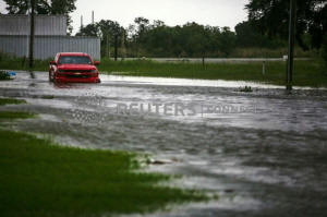
A car near Vermilion Bay is seen partially submerged in waters
brought by Hurricane Laura approaching Abbeville, Louisiana, U.S.,
August 26, 2020. REUTERS/Kathleen Flynn

"People need their vodka," said Janaka Balasooriya, a cashier, who
said he lived a few blocks away and would ride out the storm at
home.
The area where Laura made landfall is marshy and particularly
vulnerable to the storm surge of ocean water.
"This is one of the strongest storms to impact that section of
coastline," said David Roth, a forecaster with the National Weather
Service. "We worry about that storm surge going so far inland there
because it's basically all marshland north to Interstate 10. There
is little to stop the water."
The storm surge could penetrate inland from between Freeport, Texas,
and the mouth of the Mississippi River, and could raise water levels
as high as 20 feet (6 meters) in parts of Cameron Parish, Louisiana,
the NHC said.
"To think that there would be a wall of water over two stories high
coming on shore is very difficult for most to conceive, but that is
what is going to happen," said National Weather Service
meteorologist Benjamin Schott at a news conference.
"The word 'unsurvivable' is not one that we like to use, and it's
one that I've never used before," Schott said of the storm surge.
Temporary housing was hastily organized outside the surge zone for
evacuated residents, and emergency teams were being strategically
positioned, state and federal emergency management agencies said.
Laura was also expected to spawn tornadoes on Thursday over
Louisiana, far southeastern Texas and southwestern Mississippi, with
widespread flooding likely from far eastern Texas across Louisiana
and Arkansas.

(Reporting by Ernest Scheyder and Julio-Cesar Chavez in Port Arthur;
Jennifer Hiller and Gary McWilliams in Houston; Liz Hampton in
Denver; Gabriella Borter in New York and Brad Brooks in Lubbock,
Texas; Writing by Gabriella Borter and Brad Brooks; Editing by
Leslie Adler, Stephen Coates and Alison Williams)
[© 2020 Thomson Reuters. All rights
reserved.] Copyright 2020 Reuters. All rights reserved. This material may not be published,
broadcast, rewritten or redistributed.
Thompson Reuters is solely responsible for this content. |