|
The
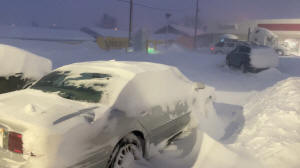
Midwest and Great Lakes region could see a major blizzard
beginning Thursday, while cold air moving east could bring a
flash freeze caused a rapid temperature drop across the country,
according to the National Weather Service.
"It does not look like a good day to be traveling across the
Midwest on Friday," said Greg Carbin, chief of forecast
operations at the NWS Weather Prediction Center. "It'll
definitely be feeling like winter almost from coast to coast."
Airports and roads from Chicago to the St. Louis areas could
suffer disruptions beginning Thursday, while the rest of the
country battles with falling temperatures, he warned.
The biggest risk exists in the states of Kansas, Nebraska and
Iowa, as well as parts of Wisconsin, Illinois, Indiana and
Michigan. Snow amounts could exceed a foot, Carbin said.
Southern states could have rainfall and thunderstorms through
Thursday, after which temperatures could drop significantly.
Wind chill temperatures in the immediate Gulf Coast could reach
30 degrees, he added.
"Wind chill temperatures will be frigid," he said.
The NWS also warned of "bone-chilling" cold in parts of
Washington state through the Northern Plain states, including
Montana, Wyoming and the Dakotas.
Parts of Montana could see the thermometer register below minus
20 degrees Fahrenheit (-29 C) on Tuesday, according to the NWS.
(Reporting by Tyler Clifford in New York; Editing by Alistair
Bell)
[© 2022 Thomson Reuters. All rights
reserved.] Copyright 2022 Reuters. All rights reserved. This material may not be published,
broadcast, rewritten or redistributed.
Thompson Reuters is solely responsible for this content.

|
|


