Tropical storm threatens to fan California wildfires, but will cool off
state
 Send a link to a friend
 [September 10, 2022]
SACRAMENTO, Calif. (Reuters)
-A tropical storm approaching Southern California on Friday threatened
to bring high winds that could whip up wildfires and heavy rainfall that
could trigger flash floods, but the system will also bring relief from a
brutal, 10-day heat wave. [September 10, 2022]
SACRAMENTO, Calif. (Reuters)
-A tropical storm approaching Southern California on Friday threatened
to bring high winds that could whip up wildfires and heavy rainfall that
could trigger flash floods, but the system will also bring relief from a
brutal, 10-day heat wave.
Tropical Storm Kay was expected to generate wind gusts of up to 100
miles per hour, potentially fanning the flames of the Fairview Fire,
which has already scorched about 27,000 acres (10,926 hectares) in
Riverside County, east of Los Angeles.
The fire, which was 5% contained, has already forced more than 35,000
evacuations.
"We could go from a fire suppression event into significant rain, water
rescues, mudslides, debris flows. We have challenging days ahead," said
Deputy Chief Jeff Veik of Cal Fire’s Riverside Unit on Thursday during a
community meeting.
Rain began in the area Friday afternoon, helping firefighters battle the
blaze, said Cal Fire spokesman Rob Roseen. By late afternoon, winds were
still slow.

The storm, which weakened from hurricane force overnight, was
threatening Baja California, other parts of Mexico and the U.S.
Southwest with heavy rains that could cause dangerous flash flooding,
landslides and mudslides, the National Weather Service (NWS) said.
Parts of Baja California could see more than 10 inches (25 cm) while
spots in Southern California could get 6 to 8 inches of rain from heavy
downpours as Kay pushes inland on Friday and into the weekend, the
service said.
"Extended periods of moderate to heavy rain will be capable of producing
rural and urban flooding," the service said. "Those living in areas
prone to flooding should be prepared to take action."
Strong easterly winds of 40 to 50 mph with gusts up to 100 mph were also
in the forecast for Southern California, the NWS said, warning that
gusts could down trees and power lines and make travel difficult.
COOLER TEMPERATURES
The storm will also give California much-needed relief from the
scorching heat wave it has endured over the last 10 days, NWS
meteorologist Bill South said.
It "will move over us tomorrow and provide us with some cloud cover and
maybe some light rain and much cooler temperatures," he said.
Still, temperatures on Friday reached 101 degrees Fahrenheit at Los
Angeles International Airport, breaking a record of 96 degrees
Fahrenheit set in 1984, the National Weather Service said on Twitter.
[to top of second column]
|

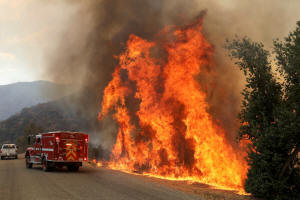
Flames grow next to a fire engine as the Fairview Fire burns near
Hemet, California, U.S., September 7, 2022. REUTERS/David
Swanson/File Photo

In the state capital of Sacramento, temperatures were expected to
reach 106 degrees Fahrenheit. The region has suffered from
temperatures well above 100 degrees Fahrenheit all week.
The forecast of cooler temperatures follows a string of days when
conservation efforts helped the power grid avoid rotating outages,
according to the California Independent System Operator (ISO), grid
operator for most of the state.
ISO Chief Executive Elliot Mainzer said that while the lower
temperatures were decreasing, overall demand for electricity, cloud
cover and smoke would reduce the state's critical supplies of solar
energy by as much as 60% compared to earlier in the week.
"Our colleagues down in Southern California today really have their
work cut out for them as we go from one extreme weather condition to
the next," Mainzer said, noting utilities could also face challenges
keeping the lights on if heavy rain and winds prompt floods or
mudslides.
By mid-afternoon, however, his agency's website showed that demand
for energy was not outstripping supply.
Edison International's Southern California Edison utility, which
serves five million customers in the southern third of California,
was considering shutting off power to about 53,000 customers on
Friday in order to lessen the risk of power lines igniting
wildfires.
"The utility's concern is the short window of time before the rains
start. We don't want any of the utility's equipment to cause
wildfires during that time," said company spokesman David Song.
The grid came close to imposing rotating outages on Tuesday, when
power demand hit an all-time high and electric prices spiked to
two-year highs.

The ISO wants consumers to conserve energy during the late afternoon
hours when the sun begins to go down and less solar power is
generated. Renewable energy including solar power has provided about
a third of the grid's electricity during the middle of the day, but
far less once evening falls.
(Reporting by Scott DiSavino, Brendan O'Brien and Sharon Bernstein;
editing by Bill Berkrot, Alistair Bell, Aurora Ellis and Diane
Craft)
[© 2022 Thomson Reuters. All rights
reserved.]
This material may not be published,
broadcast, rewritten or redistributed.
Thompson Reuters is solely responsible for this content. |