What caused the record rainfall in Beijing and northern China?
 Send a link to a friend
 [August 02, 2023]
By Ethan Wang and Ryan Woo [August 02, 2023]
By Ethan Wang and Ryan Woo
BEIJING (Reuters) - Extreme rain battered Beijing, Tianjin and the
province of Hebei in the wake of Typhoon Doksuri in late July, causing
widespread flooding and damage in a region the size of Britain.
The storms, which have killed at least 20 people and led to the
displacement of hundreds of thousands of residents, were the worst to
hit China in over a decade, with Beijing experiencing its heaviest
rainfall in 140 years.
HOW SEVERE WAS THE RAINFALL?
The amount of rainfall since Saturday has breached many local
meteorological records.
A reservoir in Beijing's Changping district logged a precipitation
reading of 744.8mm (29.3 inches) between Saturday and Wednesday, the
most in the city in over 140 years and far exceeding the previous record
of 609mm set in 1891.
The persistent downpour prompted Beijing to use a flood storage
reservoir for the first time since its establishment 25 years ago to
divert floodwater.
In Hebei, one local weather station recorded 1,003mm of rain for a
three-day period from Saturday to Monday, an amount normally seen over a
year and a half.

HOW DID THE EXTREME RAIN HAPPEN?
Besides the remnants of Doksuri, warm and humid air-flows and water
vapor brought by Typhoon Khanun slowly moving in the Western Pacific
created the conditions for the heavy rains, according to Chinese
meteorologists.
As the residual circulation of Doksuri's rain clouds headed north, a
subtropical and continental high pressure system in the atmosphere also
blocked their north and eastward passage, leading to the continuing
convergence of water vapor that acted like a dam storing the water, the
meteorologists say.
Topographic features in the area also contributed to the weather. As
large amounts of vapor gathered in northern China, it was then lifted up
by a low-altitude wind, shifting precipitation east of the Taihang
mountain range, where the worst-hit areas - including Beijing's Fangshan
and Mentougou districts - are located.
[to top of second column]
|

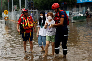
Rescue workers help residents through
floodwaters after remnants of Typhoon Doksuri brought rains and
floods, in Beijing, China August 2, 2023. REUTERS/Tingshu Wang

Meanwhile, a series of convective clouds gathered over the area,
resulting in heavy rainfall for a protracted period of time, further
exacerbating the damage and complicating rescue operations.
HOW DAMAGING WAS THE RAIN?
In the urban parts of Beijing, hundreds of roads were flooded,
forcing parks and tourism spots to shut. Hundreds of flights were
either delayed or cancelled at the city's two major airports. Some
subway lines and trains were also suspended.
The impact was more pronounced in the city's western suburbs. In
Mentougou and Fangshan districts, raging water coursed down roads,
sweeping away cars. Villages in mountainous areas were cut off,
prompting authorities to deploy helicopters to drop off food, water
and emergency supplies.
Hebei's Zhuozhou, a city with more than 600,000 people to the
southwest of Beijing, was half-submerged, with about 134,000
residents affected and one-sixth of the city's population evacuated.
HAVE SIMILAR WEATHER EVENTS HAPPENED IN THE PAST?
Rain with intensity seen in the latest event following weakened
typhoons is unusual in Beijing and its surroundings. The Chinese
capital has observed at least 12 incidences of significant rain
brought by typhoons since authorities started keeping records,
according to state media.
In 2017 and 2018, Typhoon Haitang and Ampil both dumped over 100mm
of rain on Beijing. One of the most significant rain events was
caused by Typhoon Wanda in 1956, which unleashed more than 400mm of
precipitation in the densely populated city.
(Reporting by Ethan Wang and Ryan Woo; editing by Miral Fahmy)
[© 2023 Thomson Reuters. All rights
reserved.]This material may not be published,
broadcast, rewritten or redistributed.
Thompson Reuters is solely responsible for this content.
 |