|
The
storm has sustained winds of 60 mph (95 kph) and could reach
Category 2 strength with sustained winds of 96 to 110 mph when
it is forecast to make landfall in Florida on Wednesday,
according to Governor Ron DeSantis.
The governor said the hurricane could make landfall in northern
Florida's Big Bend area - where the panhandle transitions into
the peninsula.
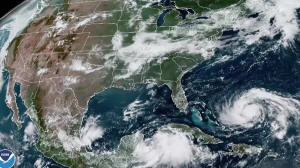
The U.S. National Hurricane Center (NHC) said on Sunday that the
storm is currently near the Yucatan Channel about 145 miles (235
km) south of the western tip of Cuba.
Idalia could cause scattered flash and urban flooding from heavy
rains along parts of Florida's west coast, the Panhandle and
southern Georgia late Tuesday night through Wednesday, the
Miami-based weather forecaster said.
"Idalia is likely to be near or at major hurricane intensity
when it reaches the Gulf coast of Florida," the NHC added.
DeSantis declared a state of emergency for 33 Florida counties
on Saturday.
"If you are in the path of this storm, you should expect power
outages, so please prepare for that," DeSantis said during a
Sunday briefing with Florida's Division of Emergency Management.
The governor said power company workers were preparing ahead of
the storm and that 1,100 members of the National Guard were
mobilized with 2,400 high-water vehicles and a dozen aircraft
for rescue and recovery efforts.
Duke Energy is closely monitoring the approach of Idalia and
preparing crews and equipment to respond if customers lose
power.
President Joe Biden had been briefed about Idalia's forecast
path and will be kept up to date as the storm moves, the White
House said on Sunday.
(Reporting by Baranjot Kaur and Deep Vakil in Bengaluru, Maria
Caspani in New York, and Katharine Jackson and Trevor Hunnicutt
in Washington; Editing by Lisa Shumaker and Lincoln Feast)
[© 2023 Thomson Reuters. All rights
reserved.] Copyright 2022 Reuters. All rights reserved. This material may not be published,
broadcast, rewritten or redistributed.
Thompson Reuters is solely responsible for this content.

|
|


