Pacific storm douses California, flooding roads, in first of one-two
punch
 Send a link to a friend
 [February 02, 2024]
By Steve Gorman and Jorge Garcia [February 02, 2024]
By Steve Gorman and Jorge Garcia
LOS ANGELES (Reuters) - The first in a one-two punch of atmospheric
river storms soaked Southern California with drenching rains on
Thursday, triggering scattered flooding and rush-hour road closures in a
precursor to a larger, wetter blast expected to sweep ashore over the
weekend.
The city of Long Beach, just south of Los Angeles, was one of the
hardest-hit areas, with rainwater flooding a stretch of freeway and
adjacent streets beneath a railroad bridge, leaving several vehicles
submerged up to their roofs.
At least one motorist, Franklin Capitulo, 54, a hotel employee who was
driving home from work, had to be rescued after his car stalled in the
middle of an inundated roadway, leaving him trapped in his vehicle as
water steadily rose around him.
"I ran into this water, but I didn't expect it was that deep already,"
said Capitulo, recounting that he grew panicky and called his brother
for help, and was ultimately pulled through a window by firefighters who
arrived at the scene.
Flooding, mud flows and rock slides forced the closure of numerous other
roads across the region, including a busy tunnel passage that connects
Pacific Coast Highway with a freeway in Santa Monica and a major freeway
on-ramp in L.A.'s San Fernando Valley.

The California Highway Patrol reported at least 50 spinouts and crashes
in central Los Angeles Thursday morning, and firefighters rescued a man
trapped in an Orange County flood-control channel, according to the Los
Angeles City News Service.
A flash-flood warning was posted for Los Angeles County and flood
advisories were issued for San Diego and Orange counties. But the
storm's center passed through the region fairly swiftly, minimizing
flood threats, the National Weather Service reported.
The storm first blew into Oregon and Northern California on Wednesday
and spread south, blasting the San Francisco Bay area with intense rains
and strong, gusty winds. Heavy snow fell in the higher-elevations of
California's Sierra Nevada range.
BIGGER DELUGE STILL TO COME
A second, more potent storm was forecast to roll into California late
Saturday and Sunday, bringing high winds back to the northern part of
the state and much heavier downpours in the south, while dumping yet
more snow in the mountains.
"This system will likely produce 24 to 36 hours (or more) of continuous
rain," the weather service said in a forecast notice.
[to top of second column]
|
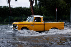
A vehicle drives through flood water in Tarzana, in the San Fernando
Valley region of Los Angeles, California, U.S. February 1, 2024.
REUTERS/Carlin Stiehl

Early estimates call for widespread rainfall totals of 2-4 inches
(5-10 cm) from Sunday through Wednesday, and likely twice that in
some foothill and low-elevation mountain areas, forecasters added.
Both storms formed from vast airborne currents of dense moisture
called atmospheric rivers. They also fit the definition of a storm
system known as a "Pineapple Express," drawing on especially warm,
subtropical waters around the Hawaiian islands.
A series of about a dozen atmospheric river storms lashed California
in rapid succession last winter, causing mass evacuations, power
outages, levee breaches and road closures in a state long
preoccupied with drought and wildfires. At least 20 people perished
in those storms, which nevertheless helped break the grip of a
years-long drought in California.
The latest storms are likewise expected to help improve the state's
water supply picture by bolstering mountain snowpacks, currently
lagging well below average levels for this time of year. Snow in the
Sierras has traditionally accounted for nearly a third of
California's freshwater supplies.
But the warmer nature of these storms relative to last year, an
apparent consequence of the prevailing El Nino weather pattern,
means California will likely receive less of the precipitation this
winter in the form of snow.
While the U.S. West Coast has averaged 10 or 11 atmospheric river
storms a year since 1980, they are projected to become more frequent
and more extreme over the next century if planetary warming from
human-induced climate change continues at current rates, according
to scientists.
Climate change also is likely to contribute to the warming effect of
Pacific storms, depressing mountain snowfall amounts, even in
otherwise wet winters, scientists say.
(Reporting by Steve Gorman in Los Angeles; Editing by Diane Craft)
[© 2024 Thomson Reuters. All rights reserved.]This material
may not be published, broadcast, rewritten or redistributed.
Thompson Reuters is solely responsible for this content.
 |