Heat wave settles in over U.S. West, raising wildfire risk
 Send a link to a friend
 [July 24, 2024]
By Liya Cui and Brendan O'Brien [July 24, 2024]
By Liya Cui and Brendan O'Brien
(Reuters) -Tens of millions of Americans living in the U.S. West endured
scorching temperatures on Tuesday while wind gusts and dry conditions
stoked dozens of wildfires, prompting evacuations across the parched
region.
Excessive heat will blanket an area stretching from the U.S. Southwest
north through Nevada and into Idaho and Montana over the next two days
before milder temperatures arrive on Friday, the National Weather
Service said. More than 20 million people are affected by the service's
advisories.
Temperatures in Phoenix and Las Vegas were expected to surpass 110
degrees Fahrenheit (43 C) by midday on Tuesday while 1,200 miles (1,900
km) to the north in Billings, Montana, a high of 107 degrees Fahrenheit
was forecast by the service.
The heat, along with persistent windy and dry conditions, has amplified
the threat of wildfires over the last few days.
About 20 fires were burning throughout the state, scorching more than
100,000 acres (40,470 hectares) so far, said the California Department
of Forestry and Fire Protection. Three of the fires were 98% contained
as of Tuesday morning.
In Riverside, California, about 55 miles (88 km) east of Los Angeles, a
blaze that began on Sunday destroyed or damaged more than a dozen homes
over the past two days. The Hawarden Fire, which was 20% contained as of
Tuesday, was sparked by fireworks, authorities said, forcing about 100
people to evacuate, injuring two residents and burning more than 500
acres, officials said.
The California blazes were among some 69 large, active fires burning in
the West, including 24 in Oregon and 9 in Arizona, according to the
National Interagency Fire Center.
The center urged residents in the region to stay vigilant and prepare to
evacuate at a moment's notice.

[to top of second column]
|
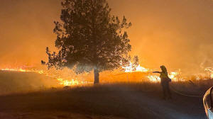
A firefighter works to extinguish the Lone Rock fire burning in
Spray, Oregon, U.S. July 21, 2024 in this screengrab obtained from a
video. Oregon State Fire Marshal/Handout via REUTERS/File Photo

The Biden administration said on Tuesday that the U.S. National
Oceanic and Atmospheric Administration (NOAA) would begin sharing
satellite data with the interior and agriculture departments in an
effort to rapidly detect and report wildfire starts.
"With more real-time information we can reduce the risks to crews
... and improve our response time reducing the risk to impacted
communities," Secretary of Agriculture Tom Vilsack said in a
statement.
Canada's Alberta Province has also been facing dozens of wildfires
in recent days, causing thousands of people to evacuate, including
an evacuation of Jasper National Park late on Monday night.
Smoke from the Canadian fires has begun to degrade the air quality
in some areas of the western U.S.
"Wildfire smoke transported from Canada and the Northwest US has led
to poor air quality conditions across much of our area," the U.S.
National Weather Service in Cheyenne, Wyoming, wrote on X.
As of Tuesday afternoon, Nampa and Boise, Idaho, and Burns, Oregon,
had the worst air quality in the U.S., with "very unhealthy
conditions" in all three locations, according to IQAir, which tracks
global air quality conditions.
(Reporting by Liya Cui in New York and Brendan O'Brien in Chicago;
Editing by Sandra Maler)
[© 2024 Thomson Reuters. All rights
reserved.]This material
may not be published, broadcast, rewritten or redistributed.
Thompson Reuters is solely responsible for this content. |