|
 El
Niño and La Niña: A Brief Overview: El
Niño and La Niña: A Brief Overview:
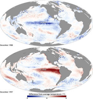
El Niño and La Niña are opposite phases of the El Niño-Southern
Oscillation (ENSO) cycle, a natural climate phenomenon originating
in the tropical Pacific Ocean. El Niño occurs when sea surface
temperatures (SSTs) in the central and eastern Pacific Ocean become
unusually warm, while La Niña involves cooler-than-average SSTs in
the same region. These phenomena can exert profound impacts on
global weather patterns, altering precipitation, temperature, and
atmospheric circulation.

Credit Image: NOAA Climate.gov
El Niño and Illinois Weather:
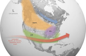
During an El Niño event, central Illinois typically will experience
shifts in its weather patterns. One of the prominent effects is a
decrease in winter precipitation, often resulting in warmer and
drier conditions across the state. This can lead to diminished
snowfall for our area.
El Niño tends to suppress the development of severe weather,
including tornadoes, during the spring and summer months in
Illinois. The warmer-than-average sea surface temperatures in the
Pacific alter the position of the jet stream, resulting in more
stable atmospheric conditions over the region. However, it's
essential to note that while El Niño generally brings milder
conditions, it does not eliminate the risk entirely, and severe
weather can still occur.

Credit Image: NOAA Climate.gov
It’s worth noting that El Niño events vary in size, intensity, and
duration. As a result, the impacts can vary from one event to the
next. In addition, there may be other factors that influence
Illinois weather during these events.
● Summers tend to be slightly cooler and wetter than average
● Falls tend to be wetter and cooler than average
● Winters tend to be warmer and drier
● Springs tend to be drier than average
● Snowfall tends to be below average
● Heating degree days tend to be below average, which means lower
heating bills.
La Niña and Illinois Weather:
Generally, La Niña impacts on Illinois weather are not as clear-cut
because there have been fewer strong ones in recent years, with the
last strong La Nina occurring in 1988-89. However, in general these
are the observed weather trends in Illinois during a La Niña:
● Summers have a tendency to be warmer and drier in Illinois
● Falls have a tendency to be cooler in the north and wetter in the
southeast
● Winters are typically warmer and wetter than average with more
snow and winter storms
● Springs tend to be cooler across most of the state and drier in
the west

This winter season's very
strong El Nino appears to have followed the typical El Nino
temperature pattern of warmer than normal conditions, as Lincoln was
5 degrees above normal for the months of December to February.
Precipitation, however, did not follow the El Nino pattern, as the
winter months had slightly above normal precipitation due to a much
above normal January and a slightly above normal December. Despite
above normal precipitation, Logan County ended up with below normal
snowfall, by about 6 inches. The lack of a frost depth for any
length of time allowed the precipitation this winter to filter into
the ground, helping to improve our drought conditions across the
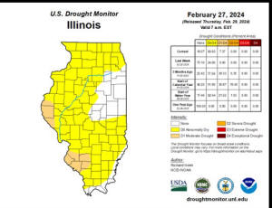
area through December and January. We ended the winter with February
drier than normal, so we did see a slight return to abnormally dry
conditions in Logan County according to the U.S. drought monitor.
[to top of second column] |


Where we are now:
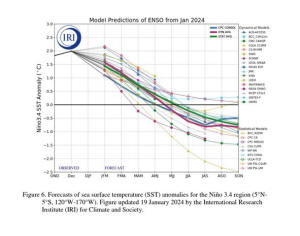
The El Nino is weakening and shifting toward ENSO Neutral
conditions. We will likely see a shift toward La Nina conditions by
June-July-August time frame, and remain La Nina into next Winter.

Impacts on Agriculture:
Since the ENSO trends are moving toward La Niña conditions this
summer, that would tend to influence the weather across central
Illinois towards warmer and drier conditions. That could pose
challenges for farmers, especially during critical growth stages.
Reduced precipitation can lead to soil moisture deficits, affecting
crop germination, development, and yields. Additionally, the
elevated risk of heat stress during La Niña summers can further
impact crop productivity, particularly for heat-sensitive crops like
corn and soybeans.
To counteract that potential trend, farmers can employ strategies
such as implementing drought-resistant crop varieties, optimizing
irrigation practices, and diversifying crop portfolios to mitigate
risks associated with varying precipitation patterns.

Looking ahead:
The current monthly and seasonal outlooks from the Climate
Prediction Center show above normal temperature trends throughout
this Spring, Summer and Fall. That could lead to more rapid drying
conditions between periods of rainfall. The Precipitation outlook
calls for above normal precipitation trends for March-April-May as
well as June-July-August. That is a good sign toward hopefully
preventing long term drought, or even flash drought conditions this
summer.
[Ed Shimon
National Oceanic and Atmospheric Administration
National Weather Service
Lincoln Illinois]
 |