|
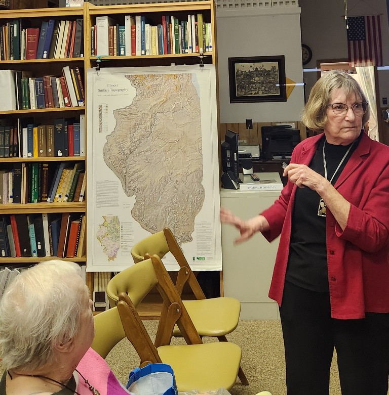
What Moriearty said she would be talking about is the
history behind history.

Though Moriearty is not a geologist, she got hooked
on geology about a year and half ago and considers herself a
geological aficionado.
On the state geological survey website, Moriearty found a button you
can click on and type in a question then get an answer from a real
geologist the next day.
Moriearty is thankful to local experts Dr. Dennis Campbell and Viper
Mine Manager Troy Kirkpatrick for helping her find information.
Other experts Moriearty has received information from are Dr. Steve
Altaner, Dr. Brandon Curry, Scott Elrick and Dr. Zak Lasemi, so she
is also thankful for their assistance.
As Moriearty started the presentation, she gave a definition of
geology, which is the science dealing with the earth’s substances,
structures made out of those substances, processes by which it [the
shaping of structures] happens and the history of it all.
In Logan County, Moriearty said we are in the middle of the North
American tectonic plate stuck. What Moriearty referred to as “sexy
geology” occurs at the edges of the plates. Faults, earthquakes,
volcanoes and one plate ramming into another pushing up a whole
mountain range happens at the edges.
Being in the middle of the plate means Logan County is “stuck” with
sedimentary rock such as limestone, sandstone and shale. Moriearty
said these rocks have been created by things settling down and
getting other layers on top of them.
An exception is that glaciers drop types of non-native rocks from
far away. Moriearty said these glaciers have left areas with some
igneous, volcanic and metamorphic rocks. She said here, we only have
native sedimentary rocks.

The geology of Logan County is “subtle” for another
reason.” Moriearty said over the years, we’ve “misplaced” about 300
million years’ worth of rock layers. It has eroded away or been
scraped away by glaciers and is not there anymore.
Towards the top of the geological time scale is the era of glaciers
and wooly mammoths. Even further back was the pre-dinosaur era
rocks. However, Moriearty said there were no dinosaurs in this area.
To understand why crops in this area are so good, Moriearty said
looking under the corn and soybeans is helpful. We can find
geological clues looking under crops.
At one point, Dennis Campbell decided to look under the corn and
soybeans by digging up soil by the Sugar Creek bank. There was a
layer carved away, so Campbell carved out an area to study the creek
bank.
Something Moriearty said Campbell noticed was the creek washing mud
away from a tree trunk. Campbell took pieces of the wood and sent it
to some geologists. Moriearty said the geologists told Campbell what
he had found was a piece of a spruce tree.
After the geologists did some carbon dating, they told Campbell the
tree was 6,000 years old. Topsoil held the tree down by stuff left
from glaciers here years ago.
Moriearty said Illinois shows evidence of more than one glacier.
Silt was carried by water and distributed throughout Central
Illinois. Unlike sand, Moriearty said silt holds water.

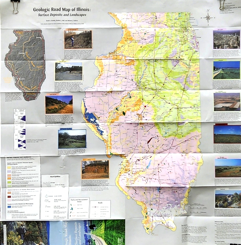
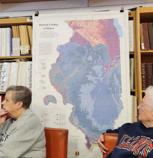
A geological road map of Illinois shows surface
deposits and landscapes. The green areas of the map show where there
was a glacier 15,000 years ago in the Wisconsin episode. Moriearty
calls it the green glacier.
The pink areas on the map show where there was a glacier 150,000
years ago in the Illinois episode. Moriearty calls it the pink
glacier. Logan County falls right on the edge and shows evidence of
both glaciers.
Red lines on the map are silt, which is finely ground rock.
Moriearty said when the glaciers melted, a lot of water flowed away
from the glacier and carried the silt with it. The silt often ended
up on the shore and dust storms and winds distributed it all over
central Illinois. Silt makes great topsoil because it will hold
water, which Moriearty said is the secret to our corn and soybeans.
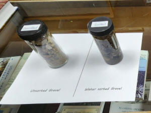
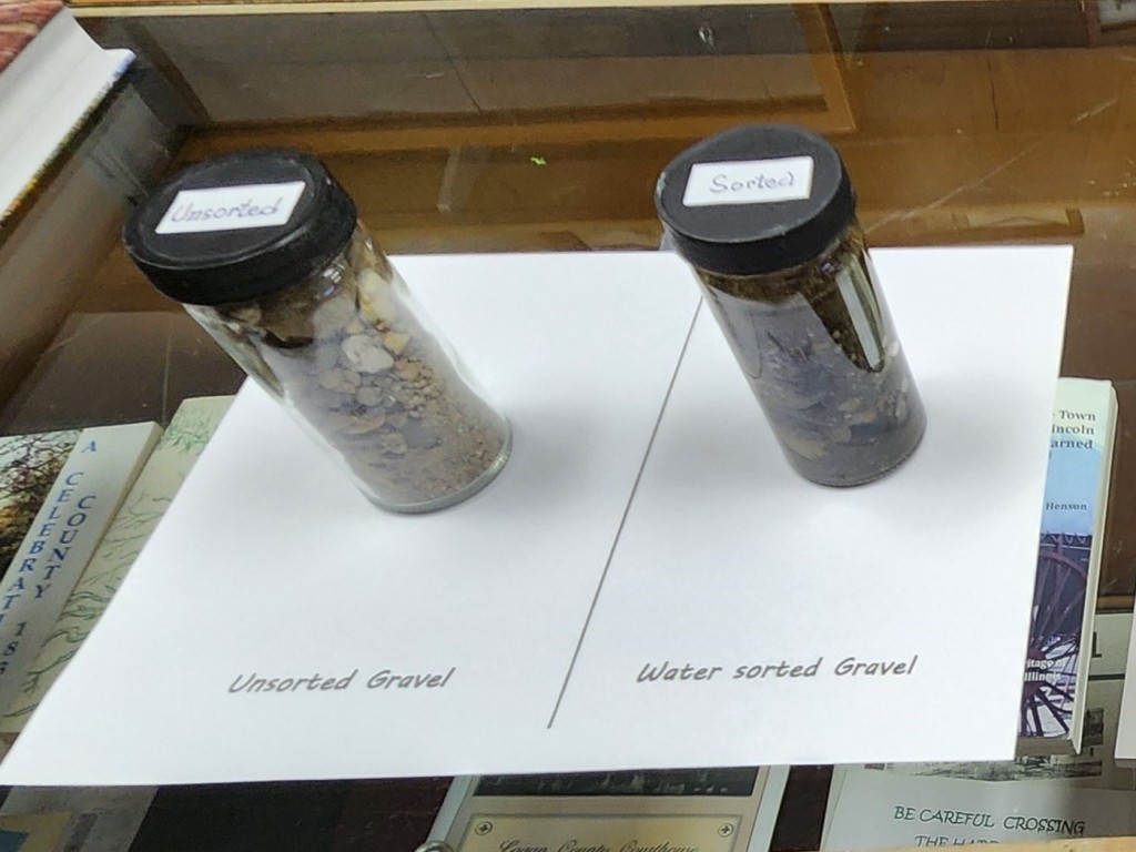
Places like Lincoln Lakes provide clues to the
county’s geological history. Moriearty said these lakes were made
from sand and gravel pits. Around 1906, Lincoln Sand and Gravel
removed sand and gravel for construction through dredging it out of
the ground. The gravel was then further sorted for sale. She said
geologists looked at the gravel and wood samples from there and
dated them between 8,000 and 12,000 years old, which would be from
the “green” glacier.
At 777 feet above sea level, Moriearty said Elkhart Hill is the
highest point in the county. Some of the sand and gravel there was
deposited from the “pink” glacier 150,000 years ago. Since the sand
and gravel there has not been sorted or cleaned up, Moriearty said
it looks different than what would be found at Lincoln Lakes.
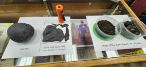
Alongside Interstate 55 or Old Route 66 and some railroad tracks,
Moriearty said people will see the Viper Mine conveyer belt used for
coal mining. Years ago, she said much of the east part of Lincoln
had coal mines and “coal was king.”
Over 300 million years ago in the “Pennsylvanian Era,” Moriearty
said Logan County had a subtropical climate. It was home to lush
marshy forests and swamps. Every once in a while, Moriearty said
water levels rose and were covered by ocean water.

During the period before the glaciers melted,
Moriearty said North America was sitting near the equator. This
period was before the continents drifted apart. When glaciers
melted, the water level rose, and we got salt water. As it got
cooler and glaciers formed again, Moriearty said all the water was
tied up in the glaciers, so the water level went down and there was
dry land in the area.
The result of shifting sea levels was a very complex set of layers
of sedimentary rock being set down. Moriearty said there may have
been sandstone, shale and freshwater limestone when we were under a
lake. She said limestone is made from dead critters in the water
falling down and their outer layers turning into rock.
When the water level went up and we were under the ocean, Moriearty
said we would have marine limestone and then shale if close to the
shore and mud washed in under the water. There would then be more
layers of limestone and of shale.
Below that, Moriearty said there was a layer of coal, then underclay,
freshwater limestone, sandy shale or siltstone and finally
sandstone.
To study these layers, Moriearty said geologists drill out a
cylindrical rock core and go through it layer by layer analyzing it
to see what it is, what was growing there and when it was happening.
On the top six layers, Moriearty said predominantly marine fossils
can be found. In the next several layers, fossils would be
predominantly non marine.
[to top of second column]
 |

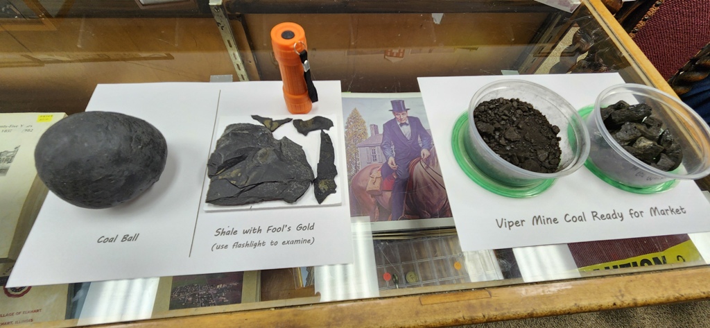
For coal formation, Moriearty said time, pressure and
heat are needed. It starts out as peat, then produces lignite,
sub-bituminous and bituminous (soft) coal. Bituminous coal is the
kind we have. She said if water starts seeping down from layers
above the coal, it can carry impurities with it.
Calcium can come down. Moriearty said the calcium may
come from the limestone layer. If the calcium reacts with a plant
material, she said it turns the plant material into fossils. These
pieces cannot go on to be coal and they are harder. The fossils sit
there in the coal, which becomes a problem for coal miners.
When this coal is taken out and processed, it creates
coal balls. Moriearty said geologists love the coal balls because
they can be sliced in half to show what is inside.
Something else that can happen is Fools’ gold, which Moriearty said
is iron sulfide and adds sulfur to coal. We have high sulfur coal,
which must be scrubbed before letting it out of a chimney after it
is burned. She said the Fools’ gold comes from the layer of shale
above the coal. The Fools’ gold causes problems too.
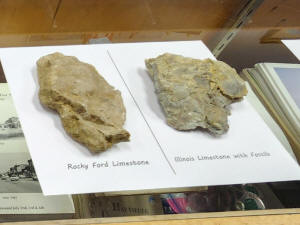
Out past Fifth Street is Rocky Ford with square
lakes. For many years, Moriearty said Rocky Ford was a limestone
quarry. She asked whether the limestone was freshwater or saltwater
limestone.
Geologists do limestone analysis through chemical tests. Moriearty
said when acid is dripped onto limestone, the limestone foams. It is
the same principle used to get the scale out of coffee makers by
running vinegar through it to get out calcium deposits.
Geologists also do fossil analysis, which Moriearty said shows some
of the fossils came from the ocean.
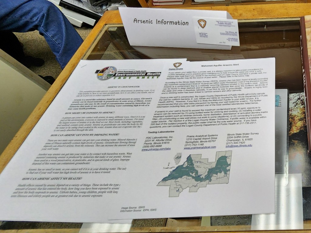
The water in Logan County comes from the Mahomet Aquifer, which
Moriearty said gives more geological clues. To make an aquifer, she
said a waterproof bottom is needed, just like in a bathtub.
Something good to use is a groove in the bedrock
carved by an ancient river. In the bedrock of Illinois, Moriearty
said there are huge grooves that are ancient riverbeds. The grooves
are then filled with sand and gravel and saturated with water. For
the confined aquifer, she said a lid would be made from a layer of
clay.
Some aquifers do not have a lid and Moriearty said those are
unconfined aquifers. Most people on a well would have an unconfined
aquifer. When there is a dry period and the water table goes down,
the well goes down.
If you are on a confined aquifer, Moriearty said the pressure of the
water going through [the aquitard] pushes the water above the water
table.
Boring into these parts is what produces water.
Moriearty said the Mahomet Aquifer is critical to central Illinois
with more than half a million people getting water from it. She said
the latest figures show close to 800,000 people getting water from
the Mahomet Aquifer.
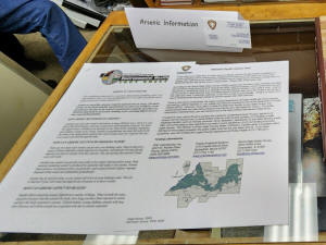
Threats to the aquifer come from both natural and
manmade pollution. Moriearty said things can seep from the ground to
the aquifer and one of the worst things is arsenic. Derivatives from
Fools’ gold can get into open wells, so she said regular testing of
wells is recommended to make sure they are not getting contaminated.
Manmade pollution can come from agriculture, factories, industry and
people in general.
Threats also come from recharging. Moriearty said when water is
sucked out of the aquifer faster than it comes in, it can suck
aquifers dry. Out west in the high plains, she said aquifers are
being used for irrigation.

Fortunately, Moriearty said the federal government
has designated the aquifer as a sole source water supply. It means
the aquifer is the only source of water possible for a lot of
people. Because of being the only source, she said it means we get
funding and support for it. There are test wells in the aquifer to
constantly monitor the water.
If you are going to start a new business, industry, factory or large
agricultural livestock farm, Moriearty said you have to submit plans
to the government. The government must approve the plan to help
ensure you are not putting concentrated pollutants into the aquifer.
We do not see much of our geology. Moriearty has driven past these
areas hundreds of times during her lifetime and said she has not
thought about what was going on that she could not see.
For Moriearty, the bottom line is “geology shouldn’t be out of
sight, out of mind—it’s not set in stone.” She said if we take care
of our geology, it will take care of us.
After Moriearty finished her presentation, she asked if there were
any questions.
LCGHS member Bill Donath asked about the depths of covered and
uncovered wells.
With these wells, Moriearty and others said it depends on where you
are. In some places it is 300 feet and in other places it is 200
feet. They are higher at the east end and lower at the west end.
One member had read about growing mushrooms in old coal mines.
If there is good temperature control, Moriearty said it would be
possible for mushrooms to grow in old mines.
In present day coal mines, Moriearty said walls of the mine shafts
are coated with white to prevent coal dust from igniting.
Once Moriearty finished her presentation, there was a short business
meeting followed by refreshments.
Questions about Moriearty’s research and presentation can be
addressed to her directly at
plmoriearty@gmail.com.
The next LCGHS meeting will be Monday, April 15. Gary Dodson will
share a presentation on the beginnings of the Edwards Trace.
[Angela Reiners]

More resources:
“Ask a Geologist.” Illinois State Geological Survey, University of
Illinois,
https://airtable.com/apppWBp5tw
X8IGIi8/shrTRzoJvyso1L9Nt
Kolata, Dennis R. and Cheryl Nimz Geology of Illinois. Champaign,
Il: University of Illinois, Illinois State Geological Survey, 2010.
McDonald, Mark. “Illinois Stories: Viper Mine” 2013, YouTube WSEC-TV/PBS.
https://www.youtube.com/watch?
v=wLffarjDTDM
University of Illinois, U.S. Department of Agriculture, Local
Extension Councils cooperating.
|