'Firehose' storm hits part of North Carolina and scientists see climate
change
 Send a link to a friend
 [September 18, 2024]
By JEFFREY COLLINS and ISABELLA O'MALLEY [September 18, 2024]
By JEFFREY COLLINS and ISABELLA O'MALLEY
The Carolinas braced for a storm that forecasters warned could bring
heavy rain — as much as 6 to 8 inches in some spots. But one narrow band
got a “firehose” that dumped as much as 20 inches in a so-called
1,000-year flood that shocked many with its intensity.
The storm that left homes flooded, cars submerged and schools closed
Tuesday in parts of North Carolina wasn’t really a surprise to
scientists who have long said that such rainfalls are one marker of
climate change.
“Data shows one of the strongest relationships between climate change
and precipitation is that as the atmosphere warms, the capacity to hold
water increases. Therefore we see more intense rainfall in a shorter
period of time,” said Andrew Kruczkiewicz, senior researcher at the
Columbia Climate School at Columbia University.
Monday’s deluge centered on Carolina Beach south of Wilmington, where
more than 18 inches (46 centimeters) of rain fell in 12 hours and almost
21 overall. That much rain qualifies as a 1,000-year flood expected only
once in that length of time, meteorologists at the National Weather
Service office in Wilmington said.
Some areas were hit particularly hard as the storm took a narrow path
over the region, “causing a bit of a firehose effect,” NWS meteorologist
Lauren Warner said. The agency’s forecasts allowed for “locally higher”
amounts, but those weren’t close to what eventually fell.

“If that had moved just a little to the left or continued l the left,
that would have mitigated some of the totals that we saw or perhaps
spread them out over a wider area,” said Warner. The worst flooding
occurred over parts of just two counties, her colleague Tim Armstrong
said.
Ocean Isle Beach, just a little over 30 miles (48 kilometers) from
Carolina Beach picked up less than 4 inches (10 centimeters) of rain.
Carolina Beach Mayor Lynn Barbee said the 21 inches that fell on his
town was impossible to fully prepare for even in a place accustomed to
tropical downpours.
“I don’t think I’ve ever seen it rain so hard and for so long,” said
Barbee, who has lived on the coast for most of his life. “Not rain bands
that get harder and let up or a front moving through. It just sat on top
of us.”
The storm system was known as Potential Tropical Cyclone No. 8, but it
never organized enough to become the eighth named tropical storm of the
season.
The lack of a name added to the difficulty, Barbee said, since people
pay more attention to named storms or hurricanes. Tourists were still
arriving for beach vacations Monday at the height of the deluge. One
family from Pennsylvania lost their van to the floodwaters and are in a
shelter instead of their vacation rental, the mayor said.
“We’ve developed a communication dialogue. We communicate cones of
uncertainty, expected path, time of arrival, strength on the Saffer-Simpson
scale. People know what to expect. But suddenly we’re having storms that
don’t fit on these scales,” Barbee said.
[to top of second column]
|

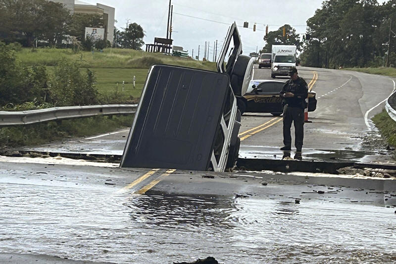
This photo provided by Brunswick County Sheriff's Office shows a
police officer checking on a vehicle that fell into a sinkhole on a
highway in Brunswick County, N.C., after a storm dropped historic
amounts of rain, Monday, Sept. 16, 2024. (Brunswick County Sheriff's
Office via AP)

Carolina Beach is still cleaning up, and the mayor expects things to be
back to normal by the weekend. But town officials are going to keep
trying to figure out how to plan for heavy rain like they plan for 18
inches of water to come in from the ocean during a hurricane’s storm
surge.
“A foot-and-a-half that falls out of the sky instead of from the ocean
-- where does it go?” Barbee said. “We’re finding it in neighborhoods
that have never flooded. It’s falling water and not rising water.”
The flash flooding closed dozens of roads in Brunswick County at North
Carolina's southeast tip, including U.S. Highway 17, which is the main
coastal route. Floodwaters swamped the highway at several points for
most of the day, trapping some drivers on high ground that became an
island.
Emergency workers brought food and water to people as they waited for
the waters to recede, Brunswick County emergency officials said. No
deaths were reported but dozens of roads in the county were damaged and
many washed out.
Gov. Roy Cooper signed an executive order Tuesday declaring a state of
emergency for Brunswick and three other southeastern counties, which the
governor said will make additional assistance available for the region.
It wasn't the region's first historic flood by any measure. The same
area has seen four other floods of a lifetime in the past 25 years from
Hurricane Floyd in 1999, unnamed storms in 2010 and 2015, and the
benchmark flood with 30 inches of rain from Hurricane Florence in 2018.
The rain from the system had moved into southeast Virginia on Tuesday.
Along North Carolina's Outer Banks, the storm closed vulnerable coastal
highway North Carolina 12 on Ocracoke Island and threatened several
homes in Rodanthe, where erosion and rising sea levels have destroyed
more than a half-dozen beachfront homes this decade.
The Atlantic hurricane season continues through the end of November.
In an updated hurricane outlook last month, the National Oceanic and
Atmospheric Administration was still predicting a highly active season
thanks to near-record sea surface temperatures and the possibility of La
Nina. Emergency management officials have urged people to stay prepared.
Elsewhere in the Atlantic, Gordon remained a tropical depression as it
swirled through open ocean waters. Gordon could either dissolve in
upcoming days or strengthen back into a tropical storm, forecasters
said.
All contents © copyright 2024 Associated Press. All rights reserved
 |