Southeast US under major storm warning as hurricane watch issued for
parts of Cuba and Mexico
 Send a link to a friend
 [September 24, 2024]
By DÁNICA COTO [September 24, 2024]
By DÁNICA COTO
SAN JUAN, Puerto Rico (AP) — Hurricane watches were issued for parts of
Cuba and Mexico on Monday as a cluster of storms south of the Cayman
Islands was expected to strengthen into a major hurricane while moving
north toward the U.S., forecasters said.
The disturbance is forecast to become Hurricane Helene on Wednesday as
it approaches the Gulf Coast, according to the U.S. National Hurricane
Center in Miami.
“It could certainly become a major hurricane, which is Category 3,” Brad
Reinhart, a senior hurricane specialist at the center, said in a phone
interview. “People in the Florida Panhandle and the west coast of
Florida certainly need to pay close attention.”
Florida Gov. Ron DeSantis declared a state of emergency in 41 counties
ahead of the expected hurricane.
Reinhart said it's too early to forecast where it might make landfall.
He warned “there's always some potential” for it to strengthen into a
Category 4 storm, but said it might not be the most likely outcome.
He said the disturbance could become a tropical storm by Tuesday, and
that tropical storm conditions could affect parts of Florida on
Wednesday as it approaches. It could turn into a major hurricane by the
time it reaches the northeast Gulf Coast on Thursday.

“It’s a pretty aggressive forecast for intensification over the next few
days,” he said. “People need to remain on high alert.”
Very warm sea temperatures are forecast to fuel formation of a tropical
storm, which is forecast to quickly strengthen into a hurricane thanks
to favorable conditions that include a moist atmosphere, which supports
thunderstorm developments, and light upper-level winds at more than
10,000 feet (around 3,000 meters), Reinhart said.
The cluster of storms was about 115 miles (185 kilometers)
west-southwest of Grand Cayman early Tuesday. It had maximum sustained
winds of 35 mph (55 kph) and was moving northwest at 6 mph (9 kph).
A hurricane watch was in effect for the Cuban province of Pinar del Rio
and eastern Mexico from Cabo Catoche to Tulum. A tropical storm warning
was in effect for Grand Cayman; eastern Mexico from Rio Lagartos to
Tulum; and for the Cuban provinces of Artemisa, Pinar del Rio and the
Isle of Youth. A tropical storm watch was in effect for Florida's Dry
Tortugas and the Lower Keys south of Seven Mile Bridge.
[to top of second column]
|
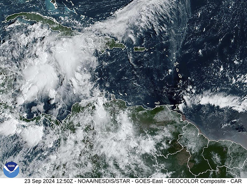
This image provided by the National Oceanic and Atmospheric
Administration shows a cluster of storms located south of the Cayman
Islands which are expected to strengthen in upcoming days, Monday,
Sept. 23, 2024. (NOAA via AP)

“While it is too soon to pinpoint the exact location and magnitude of
impacts, the potential for life-threatening storm surge and damaging
hurricane-force winds along the coast of the Florida Panhandle and the
Florida west coast is increasing," the center said in a statement.
Up to 8 inches of rain is forecast for western Cuba and the Cayman
Islands with isolated total of some 12 inches (30 centimeters). Up to 4
inches (10 centimeters) of rain is expected for the eastern Yucatán
Peninsula, with isolated total of more than 6 inches (15 centimeters)
inches.
Heavy rainfall also is forecast for the southeast U.S. starting on
Wednesday, threatening flash and river flooding, according to the
National Hurricane Center. Up to 6 inches (15 centimeters) of rain was
forecast for the region, with isolated totals of 10 inches (25
centimeters).
Meanwhile, up to 4 feet (1.2 meters) of storm surge is forecast for
parts of Cuba and Mexico.
On Monday, authorities in the Cayman Islands closed schools as
forecasters warned of heavy flooding associated with the disturbance,
which is due to cut a path between Cuba and Mexico's Yucatan Peninsula
late Tuesday night.
The Cayman Islands was already experiencing elevated tides unrelated to
the cluster of storms, and waves of up to 10 feet (3 meters) are
expected, said Shamal Clarke with the Cayman Islands Weather Service.
“Flooding will become an issue for a lot of residents,” he said.
Helene would be the eighth named storm of the Atlantic hurricane season
which runs from June 1 to Nov. 30.
The National Oceanic and Atmospheric Administration has predicted an
above-average Atlantic hurricane season this year because of record-warm
ocean temperatures. It forecast 17 to 25 named storms, with four to
seven major hurricanes of Category 3 or higher.
All contents © copyright 2024 Associated Press. All rights reserved
 |