More torrential rain and flash flooding expected in heavily waterlogged
South and Midwest
[April 05, 2025]
By GEORGE WALKER IV and BRUCE SCHREINER
HOPKINSVILLE, Ky. (AP) — Another round of torrential rain and flash
flooding was expected to hit Saturday in parts of the South and Midwest
already heavily waterlogged by days of severe storms that in some cases
spawned deadly tornadoes.
Round after round of heavy rains have pounded the central U.S., leading
to rapidly rising waterways and prompting a series of flash flood
emergencies Friday night in Missouri, Texas and Arkansas. Meanwhile,
many communities were still reeling from tornadoes that destroyed entire
neighborhoods and killed at least seven people earlier this week.
In Frankfort, Kentucky, floodwaters swept a 9-year-old boy away while he
was walking to a school bus stop Friday morning, Gov. Andy Beshear said
on social media. Officials said Gabriel Andrews' body was found about a
half-mile from where he went missing.
The downtown area of Hopkinsville, Kentucky — a city of 31,000 residents
72 miles (116 kilometers) northwest of Nashville — was submerged Friday.
A dozen people were rescued from homes, and dozens of pets were moved
away from rising water, a fire official said.
Tony Kirves and some friends used sandbags and a vacuum to try to hold
back rising waters that covered the basement and seeped into the ground
floor of his photography business in Hopkinsville. Downtown was “like a
lake,” he said.
“We’re holding ground,” he said. “We’re trying to maintain and keep it
out the best we can."
Flash flood threat looms over many states
Flash flood emergencies were issued Friday night in at least seven
cities in Missouri, Texas and Arkansas, according to the National
Weather Service.

One was in Van Buren, Missouri, where there were at least 15 water
rescues amid heavy rainfall and a rapidly rising Current River, said
Justin Gibbs, weather service meteorologist. Another was in Texarkana,
Texas, where the flooded streets resulted in several people having to be
rescued from their vehicles, according to the city's police department.
“If you don’t have darn good reason for being out (like one that
involves a visit to the emergency room), please stay home and off the
roads!!” the police department said on social media.
Heavy rains were expected to continue in parts of Missouri, Texas,
Arkansas, Kentucky and elsewhere Saturday and could produce dangerous
flash floods. The weather service said 45 river locations in multiple
states were expected to reach major flood stage, with extensive flooding
of structures, roads and other critical infrastructure possible.
In Christian County, Kentucky, which includes Hopkinsville, 6 to 10
inches (15.2 to 25.4 centimeters) fell since Wednesday evening, the NWS
said Friday afternoon. The rain caused the Little River to surge over
its banks, and 4 to 8 inches (10.2 to 20.3 centimeters) more could fall
by Sunday, it said.
Hundreds of Kentucky roads were impassable Friday because of
floodwaters, downed trees or mud and rock slides, and the number of
closures were likely to increase with more rain Saturday, Beshear said.
Flash flooding is particularly worrisome in rural Kentucky where water
can rush off the mountains into the hollows. Less than four years ago,
dozens died in flooding in the eastern part of the state.
[to top of second column]
|
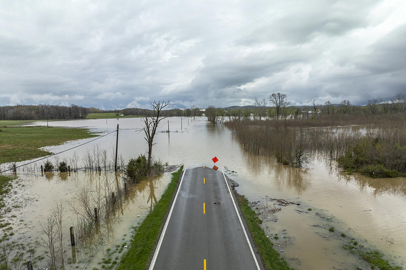
Floodwaters cover Kentucky Route 39 in Lincoln County, Ky., on
Friday, April 4, 2025. (Ryan C. Hermens/Lexington Herald-Leader via
AP)

Extreme flooding across a corridor that includes Louisville,
Kentucky and Memphis — which have major cargo hubs — could also lead
to shipping and supply chain delays, said Jonathan Porter, chief
meteorologist at AccuWeather.
Swollen rivers and tributaries also swamped some parts in Ohio on
Friday, and Gov. Mike DeWine said about 70 roads were closed. The
southern half of the state was expected to see moderate flooding,
which has not happened in four years, he added.
Forecasters attributed the violent weather to warm temperatures, an
unstable atmosphere, strong wind shear and abundant moisture
streaming from the Gulf. At least 318 tornado warnings have been
issued by the NWS since this week’s outbreak began Wednesday.
The outburst comes at a time when nearly half of NWS forecast
offices have 20% vacancy rates after Trump administration job cuts —
twice that of just a decade ago.
Tornadoes leave a path of damage, and more could be coming
At least two reports of observed tornadoes were noted Friday evening
in Missouri and Arkansas, according to the NWS.
“TAKE COVER NOW!” the weather service said on X in response to the
one on the ground around the small Missouri town of Advance.
Earlier in the week, seven people were killed in the initial wave of
storms that spawned powerful tornadoes on Wednesday and early
Thursday in Tennessee, Missouri and Indiana.
Tennessee Gov. Bill Lee said entire neighborhoods in the hard-hit
town of Selmer were “completely wiped out,” after it was hit by a
tornado with winds estimated by the NWS of up to 160 mph (257 kph).
Advance warning of storms likely saved lives as hundreds of people
sheltered at a courthouse, the governor said.
In neighboring Arkansas, a tornado near Blytheville lofted debris at
least 25,000 feet (7.6 kilometers) high, according to weather
service meteorologist Chelly Amin. The state’s emergency management
office reported damage in 22 counties from tornadoes, wind, hail and
flash flooding.
Mississippi's governor said at least 60 homes were damaged. And in
far western Kentucky, four people were injured while taking shelter
in a vehicle under a church carport, according to the emergency
management office in Ballard County.
___
Schreiner reported from Shelbyville, Kentucky. Associated Press
writers Andrew DeMillo in Little Rock, Arkansas; Jonathan Mattise in
Nashville, Tennessee; Adrian Sainz in Memphis, Tennessee; Jeff
Martin in Marietta, Georgia; Obed Lamy in Hopkinsville; John Raby in
Charleston, West Virginia; and Hallie Golden in Seattle contributed.
All contents © copyright 2025 Associated Press. All rights reserved
 |