Coastal communities restoring marshes, dunes, reefs to protect against
rising seas and storm surges
[August 18, 2025]
By TAMMY WEBBER
In San Francisco Bay, salt ponds created more than a century ago are
reverting to marshland. Along the New York and New Jersey coasts,
beaches ravaged by Superstorm Sandy underwent extensive restoration. In
Alabama, a rebuilt spit of land is shielding a historic town and
providing wildlife habitat.
Coastal communities nationwide are ramping up efforts to fend off rising
seas, higher tides and stronger storm surges that are chewing away at
coastlines, pushing saltwater farther inland and threatening ecosystems
and communities.
The need for coastal restoration has been in the spotlight this month
after Louisiana officials canceled a $3 billion project because of
objections from the fishing industry and concerns about rising costs.
The Mid-Barataria project was projected to rebuild more than 20 square
miles (32 square kilometers) of land over about 50 years by diverting
sediment-laden water from the Mississippi River.
But work continues on many other projects in Louisiana and around the
country, including barrier islands, saltwater marshes, shellfish reefs
and other natural features that provided protection before they were
destroyed or degraded by development. Communities are also building
flood walls, berms and levees to protect areas that lack adequate
natural protection.
The work has become more urgent as climate change causes more intense
and destructive storms and leads to sea-level rise that puts hundreds of
communities and tens of millions of people at risk, scientists say.
“The sooner we can make these coastlines more resilient the better,”
said Doug George, a geological oceanographer at the National Oceanic and
Atmospheric Administration.

Gulf Coast
In the U.S., perhaps nowhere is more vulnerable than the hurricane-prone
Gulf Coast. Louisiana alone has lost more than 2,000 square miles (5,180
square kilometers) of coastline — more than any other state — over the
past century, according to the U.S. Geological Survey.
Historically, sediment deposited by the Mississippi and other rivers
rebuilt land and nourished shore-buffering marshes. But that function
was disrupted by the construction of channels and levees, along with
other development.
The dangers were magnified in 2005 when Hurricane Katrina breached flood
walls and levees, submerging 80% of New Orleans and killing almost 1,400
people — followed closely by Hurricane Rita.
Afterward, the state formed the Coastal Protection and Restoration
Authority to lessen risks from storm surges and stem land loss.
Most of the almost $18 billion spent in the past 20 years was to shore
up levees, flood walls and other structures, the authority said.
Dozens of other projects are completed, planned or underway, including
rebuilding marshes and other habitat with sediment dredged from
waterways and restoring river flow to areas that have lacked it for
years.
On Louisiana’s Chandeleur Islands, a barrier island chain, the state
will pump in sand to help rebuild them, which will dampen storm surges
and benefit sea turtles and other wildlife, said Katie Freer-Leonards,
who leads development of the state’s 2029 coastal master plan.
The authority is digging a channel to allow water and sediment from the
Mississippi River to flow into part of Maurepas Swamp, a roughly
218-square-mile forested wetland northwest of New Orleans that has been
“dying for over a century” because of levees, project manager Brad
Miller said.
Sediment dredged from elsewhere also has been pumped into thousands of
acres of sinking marshes to nourish them and raise their levels.
The same is happening in other states.
In Bayou La Batre, Alabama — a fishing village built in the late 1700s —
The Nature Conservancy built breakwaters offshore, then pumped in
sediment and built ridges, now covered with vegetation. That created a
“speed bump” that has helped protect the town from erosion, said Judy
Haner, the Alabama Nature Conservancy’s coastal programs director.
[to top of second column]
|
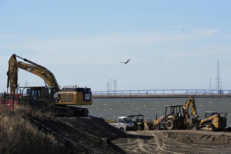
The Pond A2W site for the South Bay Salt Pond Restoration Project is
photographed Thursday, Aug. 7, 2025, in Mountain View, Calif. (AP
Photo/Godofredo A. Vásquez)

The conservancy and others also have been creating miles of oyster
reefs, and are acquiring tracts of land away from the coast to allow
habitats to move as seawater encroaches.
Such efforts won't prevent all land losses, but in Louisiana,
“cumulatively, they could make a big difference," said Denise Reed,
a research scientist who is working on Louisiana's coastal master
plan. “It could buy us some time.”
Pacific Coast
On the West Coast, communities vulnerable to sea-level rise also
could see more flooding from increasingly intense atmospheric
rivers, which carry water vapor from the ocean and dump huge amounts
of rain in a short period of time.
So tidal marshes and estuaries drained for agriculture and industry
are being restored along the entire coast, both for habitat and
coastal protection.
Habitat restoration, not climate change, was the primary
consideration when planning began about 20 years ago to restore
marshland along the south end of San Francisco Bay, destroyed when
ponds were created to harvest sea salt.
But as sediment naturally fills in ponds and marsh plants return,
“we're realizing that ... marshes absorb wave energy, storm surge
and the force of high tides,” said Dave Halsing, executive project
manager at the California State Coastal Conservancy.
That helps protect whatever is behind them, including sea walls and
land that otherwise could be inundated or washed away, including
some of California's most expensive real estate, near Silicon
Valley.
Projects also are underway along Alaska’s coast and in Hawaii, where
native residents are rebuilding ancient rocky enclosures originally
intended to trap fish, but which also protect against storm surge.
Atlantic Coast
Thirteen years after Superstorm Sandy swamped the Atlantic coast,
communities still are restoring natural buffers and building other
protective structures.
Sandy began as a fairly routine hurricane in the fall of 2012 before
merging with other storms, stretching for a record 1,000 miles and
pushing enormous amounts of ocean water into coastal communities.
But the threat of future storm surges could be even greater because
sea levels in some areas could rise as much as three feet within 50
years, said Donald E. Cresitello, a coastal engineer and senior
coastal planner for the U.S. Army Corps of Engineers.

The Corps rebuilt beaches, dunes and human-made structures from
Massachusetts to Virginia and now is turning to areas farther inland
that are increasingly vulnerable to more powerful storm surges,
Cresitello said.
“If there’s a river coming to the coast, that storm surge has the
potential to just ride up that river," depending on the storm, he
said.
A “phenomenal amount” of the U.S. population lives and works along
its coasts, so protecting those areas is important to the U.S.
economy, said George, the NOAA scientist. But it is also important
to preserve generations of culture, he said.
“When you think about why people should care ... it’s a whole way of
life,” George said.
___
Associated Press Video Journalist Stephen Smith contributed to this
report.
All contents © copyright 2025 Associated Press. All rights reserved |