Hurricane Erin picking up steam as it edges along the East Coast
[August 21, 2025]
By ALLEN G. BREED and JOHN SEEWER
RODANTHE, N.C. (AP) — Hurricane Erin began strengthening again Wednesday
as it crept closer to the mid-Atlantic coast, its outer bands brushing
North Carolina’s Outer Banks as beaches closed across much of the U.S.
East Coast.
Forecasters expect the storm to peak going into Thursday and say it
could intensify again as a major hurricane.
While Erin is unlikely to make landfall along the East Coast before
turning farther out to sea, its outer edge is packing tropical force
winds while approaching North Carolina’s Outer Banks.
Water began pouring onto the main route connecting the barrier islands
and around a handful of stilted homes precariously perched above the
beach. By Wednesday evening, officials had closed Highway 12 on Hatteras
Island as surge increased and waves were growing higher, while Ocracoke
Island's connection to its ferry terminal was cut off.
Authorities expect the largest swells during high tide will cut off
villages and vacation homes on the Outer Banks and whip up
life-threatening rip currents from Florida to New England.
New York City closed its beaches to swimming on Wednesday and Thursday.
Some beaches in New Jersey, Maryland and Delaware also will be
temporarily off-limits. The storm is expected to bring widespread,
moderate coastal flooding to low-lying areas of Long Island and parts of
New York City.

Off Massachusetts, Nantucket Island could see waves of more than 10 feet
(3 meters) later this week. But the biggest threat remained along the
Outer Banks where longtime residents didn't seem too concerned.
“I remember taking canoes out of my front yard to get to school, so I
don’t think it’s gonna be that bad,” said Jacob Throne, who lives on
Hatteras Island and works for surf shops.
Surfers flocked to the oceanfront in Virginia Beach, where Erin was
supplying robust waves for the East Coast Surfing Championships and the
kind of swells that many locals hadn’t seen in awhile.
“We’re notorious for not having waves,” said Henry Thompson, who
competed in the open long board event. “Usually we get a surf
competition and it gets canceled due to no waves or they just run it in
really bad waves.”
The championships will pause Thursday when Erin blows directly off the
Virginia coast. But Thompson said he’s expecting more hurricanes and
good surfing in the coming months.
Despite beach closures elsewhere, some swimmers were continuing to
ignore the warnings. Rescuers saved more than a dozen people caught in
rip currents Tuesday at Wrightsville Beach in North Carolina — a day
after more than 80 people were rescued.
Bob Oravec, a National Weather Service forecaster, said even if someone
thinks they know how to handle a rip current, it’s still not safe.
“You can be aware all you want,” he said. “It can still be dangerous.”

[to top of second column]
|
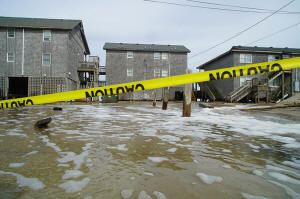
Sea water from Hurricane Erin surges under the Cape Hatteras Motel
in Buxton, N.C., on Wednesday, Aug. 20, 2025. (AP Photo/Allen G.
Breed)

A combination of fierce winds and huge waves — estimated to be about
20 feet (6.1 meters) — could cause coastal flooding in many
beachfront communities, North Carolina officials warned on
Wednesday.
“Dangerous conditions can be felt far from the eye, especially with
a system as large as Erin,” said Will Ray, the state’s emergency
management director.
Dozens of beach homes already worn down from chronic beach erosion
and protective dunes could be at risk, said David Hallac,
superintendent of the Cape Hatteras National Seashore.
The National Hurricane Center is also watching two tropical
disturbances to the east of Erin that could develop into named
cyclones. With thousands of miles of warm ocean water, hurricanes
known as Cape Verde storms are some of the most dangerous that
threaten North America.
In the Outer Banks, most residents decided to stay despite
evacuations ordered on Hatteras and Ocracoke Islands.
“We probably wouldn't stay if it was coming directly at us,” said
Rob Temple, who operates sailboat cruises on Ocracoke.
His biggest concern was whether the main route will be washed out,
and if tourists and delivery trucks will be cut off from the thin
stretch of low-lying islands that are increasingly vulnerable to
storm surges.
Erin has become an unusually large and deceptively worrisome storm,
with its tropical storm winds spreading across 500 miles (800
kilometers) — roughly the distances from New York City to
Pittsburgh.

It remained a strong Category 2 hurricane on Wednesday with maximum
sustained winds around 110 mph (180 kph), the National Hurricane
Center said. Erin was about 215 miles (346 kilometers) southeast of
North Carolina’s Cape Hatteras.
Tropical storm warnings were issued for North Carolina and Virginia,
while in Bermuda residents and tourists were told to stay out of the
water, as rough seas are expected through Friday.
Climate scientists say Atlantic hurricanes are now much more likely
to rapidly intensify into powerful and catastrophic storms fueled by
warmer oceans.
___
Seewer reported from Toledo, Ohio. Associated Press journalists
Jeffrey Collins in Columbia, South Carolina; Gary Robertson in
Raleigh, North Carolina; Ben Finley in Norfolk, Dave Collins in
Hartford, Connecticut, and Julie Walker in New York contributed.
All contents © copyright 2025 Associated Press. All rights reserved |