What to know as snow, freezing rain and bitter cold heads through much
of the US
 Send a link to a friend
 [January 04, 2025]
A major winter storm forecast to produce heavy snow,
significant ice and frigid temperatures was set to begin in the central
U.S. on Saturday and move east over the next several days, according to
the National Weather Service. [January 04, 2025]
A major winter storm forecast to produce heavy snow,
significant ice and frigid temperatures was set to begin in the central
U.S. on Saturday and move east over the next several days, according to
the National Weather Service.
Here is what to know about the storm expected to affect millions in the
eastern two-thirds of the country:
Major winter storm sets up
A large system made landfall along the West Coast on Friday afternoon,
bringing rain to the Pacific Northwest with snow expected in the Cascade
Mountains, according to meteorologists.
The system will be responsible for the development of a major winter
storm from the Central Plains to the Mid-Atlantic this weekend into
early next week.
Snow to fall throughout Central Plains and move east
By Saturday evening, widespread heavy snow is likely in areas between
central Kansas and Indiana, especially along and north of Interstate 70,
where there is a high chance of at least 8 inches (20.3 centimeters).
For places in the region that typically experience the highest snow
totals, it may be the heaviest snowfall in at least a decade,
meteorologists said.
The storm will then move into the Ohio Valley, where severe travel
disruptions are expected. It will reach the Mid-Atlantic states on
Sunday into Monday.
Blizzard conditions possible
Wind gusts higher than 35 mph (56 kph) and heavy rates of snowfall could
lead to blizzard conditions, particularly in Kansas and nearby portions
of the Central Plains by Sunday morning.
Whiteout conditions may make driving dangerous to impossible and
heighten the risk of becoming stranded.
Freezing rain expected from eastern Kansas to the Ozarks
Dangerous sleet and freezing rain, particularly detrimental to power
lines, also is anticipated to start Saturday from eastern Kansas to
Missouri, Illinois, Indiana and much of Kentucky and West Virginia.
Treacherous travel conditions are expected with power outages likely in
areas with more than a quarter-inch (a half centimeter) of ice
accumulation.
“It’s going to be a mess, a potential disaster,” private meteorologist
Ryan Maue said.
Frigid air from the Artic to blast areas as far south as Florida
Starting Monday, hundreds of millions of people in the eastern
two-thirds of the country will experience dangerous, bone-chilling air
and wind chills, forecasters said.
[to top of second column]
|

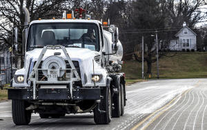
Steve Beckett with the street department in Owensboro, Ky., sprays a
salt brine solution along Hickman Avenue in preparation for
predicted snow and ice over the weekend, Friday, Jan. 3, 2025, in
Owensboro, Ky. (Greg Eans/The Messenger-Inquirer via AP, File)

Temperatures could be 12 to 25 degrees Fahrenheit (7 to 14 degrees
Celsius) colder than normal as the polar vortex stretches down from
the high Arctic.
“This could lead to the coldest January for the U.S. since 2011,”
AccuWeather Director of Forecast Operations Dan DePodwin said
Friday, noting there could be up to a week or more of "temperatures
that are well below historical average.”
The biggest drop below normal is likely to be centered over the Ohio
Valley, but significant and unusual cold will extend south to the
Gulf Coast, said Danny Barandiaran, a meteorologist at the National
Weather Service’s Climate Prediction Center.

A hard freeze is even expected in Florida, he added.
“The wind chills are going to be brutal,” Woodwell Climate Research
Institute climate scientist Jennifer Francis said. "Just because the
globe is warming doesn’t mean these cold snaps are going away.”
Weather may be triggered by a fast-warming Arctic
The brutal weather may be triggered in part by a fast-warming
Arctic, a reminder that climate change gooses weather extremes, said
Judah Cohen, seasonal forecast director at the private firm
Atmospheric and Environmental Research.
The polar vortex — ultra-cold air spinning like a top — usually
stays above the North Pole, but sometimes stretches down to the
U.S., Europe or Asia, causing intense doses of cold.
Cohen and colleagues have published several studies showing an
increase in the polar vortex stretching or wandering. Cohen and
others published a study last month attributing the cold outbreaks
partly to changes from an Arctic that is warming four times faster
than the rest of the globe.
All contents © copyright 2024 Associated Press. All rights reserved |