Millions across the US brace for plummeting temperatures and winter
storms
 Send a link to a friend
 [January 20, 2025]
By MICHAEL CASEY [January 20, 2025]
By MICHAEL CASEY
BOSTON (AP) — Residents across the country from the Northern Plains to
the tip of Maine are bracing for dangerously low temperatures as tens of
millions of residents along the East Coast contend with a thick blanket
of snow — and more snowfall in the forecast.
Winter storm warnings issued by the National Weather Service were in
effect for parts of the Mid-Atlantic through Monday morning, and
warnings began in New England on Sunday afternoon. Heavy lake-effect
snow was expected in western New York state Monday through Wednesday
morning, with 2 to 3 feet (about 60 to 90 centimeters) possible in some
areas including Oswego along Lake Ontario.
Marc Chenard, a meteorologist with the National Weather Service in
College Park, Maryland, projected that as many as 70 million residents
will be under some kind of winter storm warning in the coming days.
Return of the Arctic blast
Sunday snowfall was just the start of a chaotic week of weather. Much of
the Eastern Seaboard will be enduring some of the coldest temperatures
this winter.

An area from the Rockies into the Northern Plains will see colder than
normal weather over several days, with temperatures forecast to drop to
between minus 30 degrees Fahrenheit (minus 34 degrees Celsius) to minus
55 degrees Fahrenheit (minus 48 degrees Celsius) on Monday. Sub-zero
wind chills are forecast to reach as far south as Oklahoma and the
Tennessee Valley.
Minnesota residents were urged to wear appropriate clothing and carry a
survival kit for travel. Kristi Rollwagen, director of homeland security
and emergency management at the Minnesota Department of Public Safety,
also urged motorists to drive with a full tank of gas and a fully
charged cellphone to keep in touch with loved ones.
“It’s not something we haven’t experienced before, it’s just a good
reminder that it does get cold in Minnesota,” Rollwagen said.
Meanwhile, temperatures in Washington, D.C., are expected to dip into
the 20s (about minus 7 C to minus 1 C) with wind gusts upwards of 30 mph
(48 kph), Chenard said. The forecast prompted President-elect Donald
Trump’s inaugural ceremony to be moved inside the U.S. Capitol Rotunda.
[to top of second column]
|
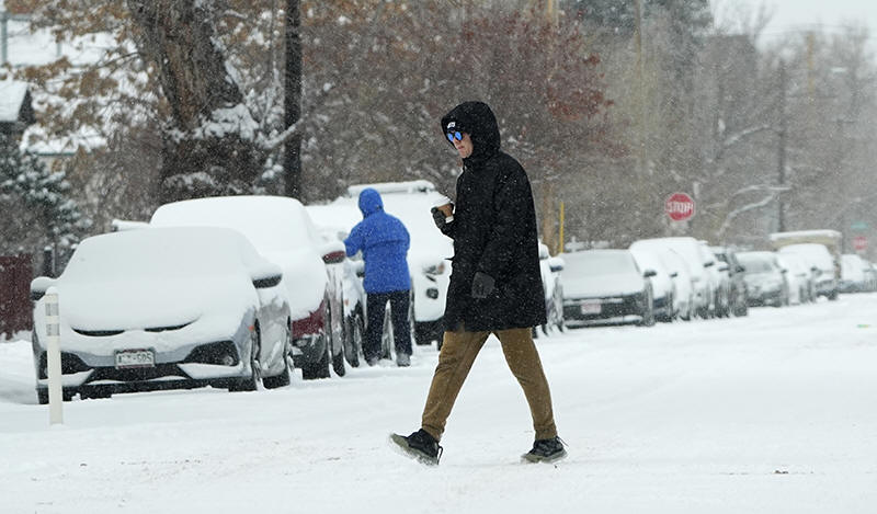
A pedestrian crosses First Avenue as a winter storm sweeps over the
intermountain West, plunging temperatures into the single digits and
bringing along a light snow in its wake Saturday, Jan. 18, 2025, in
Denver. (AP Photo/David Zalubowski)

Like earlier this month, this latest cold snap comes from a
disruption in the polar vortex, the ring of cold air usually trapped
about the North Pole.
The cold air will moderate as it moves southward and eastward, but
the Central and Eastern U.S. will still experience temperatures in
the teens and 20s Monday into Tuesday, Chenard said. The
Mid-Atlantic and Northeast also will have highs in the teens and
20s, lows in the single digits and below zero degrees F (minus 18
C), and wind chills below zero.
Unusual mix of snow, sleet and freezing rain
The colder temperatures will dip into the South early this week,
where as many as 30 million people starting Monday could see a
wintry mix of snow, sleet and freezing rain. The unusual conditions
are expected to stretch from Texas into northern Florida and the
Carolinas. Impacts are expected starting Monday night in Texas and
then spreading across the Gulf Coast and Southeast on Tuesday into
Wednesday.
Frigid air combined with a low-pressure system over the Gulf is
behind the storm, which could bring heavy snow just south of the
Interstate 20 corridor across northern Louisiana and into
Mississippi and a mix of snow, sleet, and freezing rain near the
Interstate 10 corridor from Houston to Mobile, Alabama.
Louisiana Gov. Jeff Landry on Saturday issued a state of emergency
ahead of the severe weather, urging residents to prepare and keep
watch on the forecast.
All contents © copyright 2025 Associated Press. All rights reserved
 |