As Tropical Storm Jerry churns in the Atlantic, Priscilla and a
nor'easter threaten US with flooding
[October 10, 2025]
MIAMI (AP) — Tropical Storm Jerry churned Thursday in the
Atlantic on its approach to the Leeward Islands as Tropical Storm
Priscilla and Tropical Storm Raymond moved along Mexico’s Pacific coast,
threatening heavy rain and flooding in their paths, forecasters said.
Tropical Storm Raymond was announced midday Thursday by the U.S.
National Hurricane Center in Miami, making it the third system now off
the western coast of Mexico. Post-tropical cyclone Octave was also off
Mexico's Pacific coast, but weakening.
Raymond was about 85 miles (155 kilometers) south-southeast of
Zihuatanejo, Mexico. It had maximum sustained winds of 45 mph (75 kph)
and was traveling west-northwest at 15 mph (24 kph), forecasters said.
Priscilla could bring flash flooding through the weekend across the U.S.
Southwest, the hurricane center said.
Also Thursday, Subtropical Storm Karen formed far from land in the north
Atlantic Ocean. The center said Karen was about 545 miles (880
kilometers) north-northwest of the Azores and packing maximum sustained
winds of 45 mph (75 kph). There were no coastal watches or warnings in
effect.
A subtropical storm tends to have a wide zone of strong winds farther
from its center compared to a tropical storm, which generates heavier
rains, according to the U.S. National Weather Service.
Off the coast of the U.S. Southeast, meanwhile, a storm without a name
along with unusually high King Tides because the moon is closer than
usual to the Earth threatened to bring days of heavy winds that could
cause coastal flooding, especially along the vulnerable North Carolina
Outer Banks and in frequently flooded Charleston, South Carolina.
About seven weeks remain in the 2025 Atlantic hurricane season, and
meteorologists warned the Pacific Ocean cooling pattern called La Nina,
which can warp weather worldwide and turbocharge hurricanes, has
returned.

It may be too late in the hurricane season to impact tropical weather in
the Atlantic, but this La Nina may have other impacts from heavy rains
to drought across the globe.
Tropical Storm Jerry to move past the Leeward Islands
Jerry was centered about 100 miles (160 kilometers) east of the northern
Leeward Islands and moving northwest at 17 mph (28 kph) with maximum
sustained winds of 60 mph (95 kph), the center said.
The storm was expected to pass just east of the northern Leeward Islands
on Thursday night.
Officials in the French Caribbean island of Guadeloupe warned of power
outages on Thursday, noting the island’s grid is grappling with power
generation issues that began earlier this week and that inclement
weather would worsen them.
A tropical storm warning was in effect for Barbuda and Anguilla, St.
Barthelemy and St. Martin, Sint Maarten and Guadeloupe and the adjacent
islands. A tropical storm watch was in effect for Antigua, St. Kitts,
Nevis and Montserrat and Saba and St. Eustatius, the hurricane center
said.
[to top of second column]
|

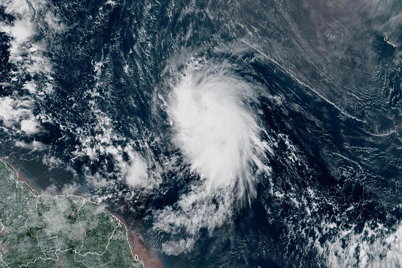
This satellite image provided by the National Oceanic and
Atmospheric Administration (NOAA) shows Tropical Storm Jerry in the
Atlantic Ocean, Tuesday, Oct. 7, 2025. (NOAA via AP)

The storm should strengthen into a hurricane Saturday. The
Nor'easter expected to send rain and pounding waves into the
Southeast U.S. is helping steer Jerry away from the islands and into
the open Atlantic, forecasters said.
Coastal storm to bring flooding tides to southeast US coast
In Charleston, the combination of the coastal storm and the higher
King Tides have forecasters predicting a high tide Friday morning of
8.5 feet (2.6 meters). That would be the 13th highest tide at the
gauge in Charleston Harbor, which has been recording data for more
than a century.
The city offered free parking in some garages starting Thursday
morning when the tide was 0.6 feet (18 centimeters) below Friday's
forecast but still flooded about a dozen streets.
Along the North Carolina Outer Banks, forecasters said the worst
weather should start Friday through the weekend. They warned it was
likely that highway N.C. 12 on Hatteras and Ocracoke islands would
likely have to close again because of ocean overwash.
More homes could fall into the sea too. Twenty-one houses have
collapsed because of rising sea levels and shifting beaches since
2020, with 10 of them destroyed by the churning waters in the past
month as Hurricanes Humberto and Imelda moved well offshore,
according to the National Park Service.
More storms in the Pacific
In the Pacific, Tropical Storm Raymond was forecast to remain off
the southwestern coast of Mexico through Friday before nearing Baja
California Sur on Saturday and Sunday. The hurricane center said the
storm would strengthen by Friday before weakening over the weekend.
A tropical storm warning associated with Raymond was issued from
Zihuatanejo to Cabo Corrientes, Mexico.
Tropical Storm Priscilla was centered about 170 miles (275
kilometers) west of Cabo San Lazaro, Mexico, and moving
north-northwest at 8 mph (13 kph) with maximum sustained winds of
about 50 mph (85 kph).
Priscilla had approached major hurricane status Tuesday before
weakening to a tropical storm on Wednesday.
The storm is expected to move into the southwestern U.S. as it
weakens further. Flood watches have been issued for parts of
Arizona, California and Nevada.
Meanwhile, the former tropical storm Octave dissipated Thursday
about 360 miles (580 kilometers) off the southern tip of Baja
California, the hurricane center said.
All contents © copyright 2025 Associated Press. All rights reserved |