Eight states, three time zones and a ton of history: Take a trip down
Route 66 as it turns 100
[April 08, 2026]
By SUSAN MONTOYA BRYAN
ALBUQUERQUE, N.M. (AP) — If you’ve ever planned to motor west and take
the highway that’s the best, this might be time: Route 66 turns 100 this
year.
The Mother Road, as author John Steinbeck dubbed it, has evolved over
the years from an escape for poor farmers fleeing the devastating dust
storms of the 1930s to perhaps the quintessential American road trip
that’s still delivering kicks.
Although there have been faster and more direct routes between the
nation’s second- and third-largest cities for some time, Route 66’s neon
still burns brightly and its vintage signs beckon travelers to restored
motor lodges, classic diners and roadside attractions.
Each stop turns the wheels of the imagination, leaving travelers to
contemplate what life was like for the people and communities that have
made the road hum over the years.
Illinois
Chicago has long been one of the country’s economic engines, with access
to international waters and railroads that linked all corners of the
country. In the 1920s, Oklahoma businessman Cyrus Avery, known as the
Father of Route 66, knew it wouldn’t be long before automobiles would
dominate the transportation landscape, and the Windy City would be the
perfect place to start the journey he envisioned.
A member of the federal highway board appointed to map the U.S. highway
system, Avery opted to go with the number 66. He knew those double
digits were ripe for marketing and could be seared into the minds of
motorists.
For some travelers, the journey is fueled more by the food than the
scenery, and there’s plenty to choose from — slices of homemade pie,
thick shakes, cheeseburgers and an assortment of fried delights.

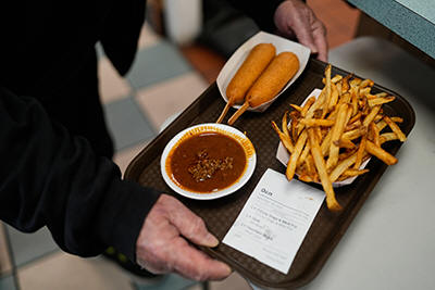
The Cozy Dog Drive In in Springfield, the Illinois capital, is one of
the many diners that sprang up along Route 66, and its breaded hot dogs
on a stick have stood the test of time. Third-generation owner Josh
Waldmire says the recipe is a secret.
Waldmire’s grandfather, Ed, saw the concoction’s potential as fast and
convenient road food and developed a system for frying the dogs
vertically.
Missouri
Route 66 has its share of twists and turns, and it’s no surprise that a
highway famous for its quirky roadside attractions would cross the
nation’s most famous river on one of the more peculiar bridges known to
modern engineering.
As the road nears St. Louis, the mile-long (1.6-kilometer-long) Chain of
Rocks Bridge hovers more than 60 feet (18 meters) above the Mississippi
River.
Engineers eventually built a straighter, higher-speed option, and a poor
resale market spared the original bridge from the scrap heap. Today it’s
reserved for pedestrians and cyclists.
A median in Missouri is home to St. Robert Route 66 Neon Park, which
features orphaned neon signs that once beckoned travelers to stop at
certain sites and businesses along the highway. Often handcrafted, they
weren’t only markers for motels, cafes and gas stations, but were also
folk art and symbols of local culture.
Kansas
The Sunflower State hosts only a short stretch of Route 66, but it packs
a punch with the Kan-O-Tex Service Station in Galena. A classic example
of roadside fare, the station served as inspiration for the animated
2006 Pixar film “Cars.”
Director John Lasseter and his crew took road trips along the route,
digging into history and looking for elements that could bring the
project to life. It was in Galena where they spotted the old boom truck
that served as the basis for the character Tow Mater. The plot wasn’t
far off, as so many once bustling towns — like the fictional Radiator
Springs — nearly faded away after being bypassed by an interstate.
Kansas also is home to the Brush Creek Bridge, otherwise known as the
Rainbow Bridge. It’s on the National Register of Historic Places and is
one of few remaining examples of the concrete arched bridges designed by
James Barney Marsh.

Oklahoma
There was a real danger for some who traveled the road, particularly
Black motorists passing through inhospitable and segregated areas during
the Jim Crow era. The Green Book — a guide first published in 1936 by
Victor Hugo Green — listed hotels, restaurants and gas stations that
would serve Black customers.
The Threatt Filling Station near Luther wasn’t listed in The Green Book,
but it was a safe haven — not only for getting fuel, but for barbecue
and baseball. Listed on the National Register of Historic Places, it was
the only known Black-owned and operated gas station along Route 66.
Route 66 is littered with abandoned buildings and faded signs, but one
example of the highway’s resilient spirit stands tall in Sapulpa, near
Tulsa. The restored Tee Pee Drive-In Theater offers a step back into the
1950s, when the booming car culture helped spawn thousands of drive-in
theaters nationwide.
Built in 1949, the drive-in officially opened in the spring of 1950 with
a screening of John Wayne’s “Tycoon.” It was one of the few drive-ins at
the time to have paved pathways. Over the years, it survived a tornado,
a fire that destroyed the concession stand and break-ins before being
shuttered for more than 20 years. It reopened in 2023.
[to top of second column]
|

A customer picks up their order at the Cozy Dog Drive In, in
Springfield, Ill., Thursday, Nov. 20, 2025. (AP Photo/Jeff Roberson)

Texas
Blink and you might miss it, but a stop at the Cadillac Ranch in
Amarillo is a must for any Route 66 journey. For decades, visitors
have been spray-painting the 10 vintage Cadillacs at the site and
mulling the transitory nature of time as Bruce Springsteen did in
his 1980 song of the same name.
It’s not a ranch, but rather a public art installation created in
1974 by the art and architecture collective Ant Farm. At first, the
cars — which were half-buried front-down at a 60-degree angle — were
used for target practice. Others would scratch their initials into
the metal. The spray painting started later.
Arrive in Adrian and you’re halfway through your trip. Steps from a
white line marking the midpoint of Route 66 is the Midway Cafe,
where the “ugly pies” are anything but.
If you’re still hungry, head back to Amarillo for a 72-ounce (2
kilogram) steak and all the sides at The Big Texan. If you can
finish the meal in an hour or less, it's free.
New Mexico
More than half of Route 66 cuts through sovereign Native American
lands, often tracing routes used by tribes long before settlers
arrived. Much like the railroad in the 1800s, the highway opened the
door to a new era of commerce, but it also fueled stereotypes about
cultures along the way.
There are still faded and crumbling references to tipis and
feathered headdresses at some stops along the historic highway. The
symbols were easily appropriated for marketing by roadside vendors
but weren't indicative of the separate and distinct Native American
cultures in the area.
Today, tribes are telling their own stories and showcasing their
creations, whether it be pottery, fruit pies or poems.
Albuquerque boasts the longest intact urban stretch of Route 66.
Those 18 miles (29 kilometers) pass through several neighborhoods
and business districts, from historic Old Town to Nob Hill.
Some of the old motor lodges and neon signs along what is now
Central Avenue have been restored. Other signs are being reimagined
using hubcaps, elaborate lowrider-inspired paint jobs and New
Mexico’s classic yellow and red license plates in a nod to the car
culture that is very much still alive in the city.

Arizona
Musician Jackson Browne was taking his own road trip in the early
1970s when his car left him stranded in Winslow. The experience
inspired the lyrics to the Eagles’ hit “Take it Easy.” But it’s
certainly not the only song that is a must-have for a Route 66
playlist.
Bobby Troup created a classic American road anthem in the 1940s with
“(Get Your Kicks on) Route 66.” Nat King Cole, Chuck Berry, The
Rolling Stones and Depeche Mode carried it through the decades, each
covering the song with their own flare.
While standing on a corner in Winslow, don’t be surprised if someone
saunters up with a guitar and starts strumming favorites from their
own road trip playlist.
Before leaving the state, the one-time gold mining town of Oatman
features a Wild West atmosphere, daily staged shootouts and beloved
burros. Oatman was a destination along one of the original
alignments of Route 66 via a treacherous path through the Black
Mountains, but it was later bypassed as part of improvements made in
the 1950s.
California
Once a desert oasis, Roy’s Motel & Café in Amboy is a quintessential
Route 66 landmark. The towering neon sign is one of the most
photographed spots along the road. Inside, foreign currency left by
international visitors lines one wall. Across the street, a clothing
post decorated with shoes, shirts and other items juts up from the
desert floor.
This stretch of the highway through the Mojave Desert offers a
special kind of solitude. The pavement gets rough in spots and the
landscape takes charge, showing off Joshua trees, wide-open spaces
and the remnants of ancient volcanic activity.
Much of the area is undeveloped, meaning it looks a lot like it
would have when Route 66 was commissioned in 1926.
After making it through oft-congested Los Angeles, the iconic Santa
Monica Pier marks the end of the line, and it’s nothing short of a
perpetual party with a steady stream of spectators and performers.
Although many stretches of Route 66 have lapsed into decay, the
breathtaking views of the Pacific Ocean are a reminder of the
pursuits made possible by the road over the last century.
___
Associated Press writers John O’Connor in Springfield, Illinois, and
Sean Murphy in Oklahoma City contributed to this report.
All contents © copyright 2026 Associated Press. All rights reserved
 |