Floodwaters inundate Wisconsin streets, trapping drivers, as Midwest
rebuilds after storms
[April 16, 2026]
By MIKE HOUSEHOLDER and COREY WILLIAMS
ANN ARBOR, Mich. (AP) — Floodwaters from record rainfall in Wisconsin
inundated streets Wednesday, trapping drivers and forcing officials to
close sections of a highway, as other Midwestern states worked to
rebuild after storms.
Cars were stranded in high floodwater on a highway in Milwaukee and
video shared by the Milwaukee Journal Sentinel showed a woman and child
being rescued from a vehicle.
The Milwaukee County Sheriff’s Office posted online to urge people not
to drive in southeast Wisconsin.
Wisconsin Gov. Tony Evers declared a state of emergency after storms,
which had started moving through the state Monday, brought strong winds,
hail and heavy rain. At least three tornadoes were confirmed and more
severe weather was expected.
Meanwhile, communities in Michigan were recovering after powerful
overnight storms damaged two ice arenas, flooded streets and uprooted
trees.
Wind gusts as strong as 70 mph (113 kph) were reported at the University
of Michigan football stadium, with similarly strong gusts at the Willow
Run Airport, meteorologist Sara Schultz said. National Weather Service
crews were surveying damage in places including Ann Arbor to determine
whether one or more tornadoes touched down.
Another round of strong storms with potentially damaging winds was
moving into the area Wednesday from states to the west.
Schools and ice arenas damaged
Some public school buildings in Ann Arbor suffered structural damage and
many lost power. The district was closed because of a fiber outage
impacting fire, phone and camera systems, and building access.
Ann Arbor Mayor Christopher Taylor said structural engineers were
assessing damage to a wall at the city's Veterans Memorial Park Ice
Arena. Part of the roof was torn from the university's Yost Ice Arena.
The storm uprooted a hulking tree outside Seungjun Lee's home in Ann
Arbor, barely missing his upstairs bedroom.
“If the tree fell down a couple more feet, I would not be standing
here,” said Lee, a 20-year-old junior at U-M.
Lee and his roommates were awakened by a siren, then an alert blasted
from their phones between 1 a.m. and 2 a.m., urging them to take
shelter.
More rain and dead fish
The storms dumped as much as 2.5 inches (6.3 centimeters) of rain across
parts of southeastern Michigan by Wednesday morning, and more was
expected across the Midwest, Great Lakes and Ohio Valley regions. Flood
watches were issued for a big chunk of Michigan's eastern Lower
Peninsula, southeastern Michigan, northern Indiana, northwestern Ohio,
the Chicago area and Wisconsin.
In northern Michigan, a power outage during a storm killed 1,750
steelhead trout at a state facility where eggs and milt are collected to
produce more fish. Scott Heintzelman of the state’s fisheries division
said it was a “devastating event” involving “big, beautiful fish.”
[to top of second column]
|

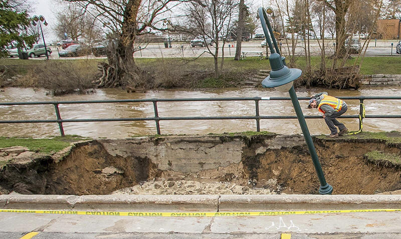
City Streets Department workers inspect a sinkhole that swallowed a
street light and parts of a sidewalk along the surging Boardman/Ottaway
River on Wednesday, April 15, 2026, in downtown Traverse City, Mich.
(Jan-Michael Stump/Traverse City Record-Eagle via AP)

Heintzelman said staff discovered Tuesday that a loss of electricity
had stopped the flow of oxygenated water, dooming the fish.
Wisconsin's Department of Natural Resources said it was watching
levees around Portage, a city of about 10,000 people, as the
Wisconsin River rises. As of Wednesday morning, the river there
swelled to nearly 19 feet (5.7 meters), about 2 feet (0.6 meters)
over flood state, and could rise to about 20 feet (6.1 meters), they
said.
After days of rainfall and winter snow melt, a “significant influx
of water” is also entering Black Lake, in northern Michigan, the
sheriff's office said.
The lake empties into the Black River and feeds the Cheboygan River,
which flows through the city into Lake Huron. Officials have been
managing that flow through the city’s Cheboygan Dam by raising
gates, adding pumps, raising a bridge and closing some riverfront to
the public.
Flooding and unsafe travel forced Cheboygan Area Schools to cancel
classes and athletic events for Thursday and Friday.
"Conditions are not improving significantly and, in some areas,
continue to worsen,” the district said.
Where's all this weather headed?
Bill Bunting, a meteorologist with the weather service’s Storm
Prediction Center, described a “very dynamic weather pattern” that
combines very moist air with a strong jet stream across the central
United States and Great Lakes to create conditions for severe
thunderstorms.
By Wednesday afternoon, the weather service had received more than
400 reports of hail, winds above 60 mph (96.5 kph) or tornadoes, he
said.
The system was stretching northward Wednesday night from central
Texas into Iowa and southern Wisconsin and then eastward across
parts of Michigan, Illinois, northern Indiana and Ohio on its way
toward upper Pennsylvania and the Buffalo, New York, area, Bunting
said.
Further east, it is expected to be as hot as a furnace, threatening
record high temperatures in New York, Philadelphia and Washington
through the weekend, forecasters say.
___
Williams reported from West Bloomfield, Michigan. Associated Press
writers Ed White in Detroit, Todd Richmond in Madison, Wisconsin,
and Hallie Golden in Seattle, contributed to this story.
All contents © copyright 2026 Associated Press. All rights reserved |