A 7.8 magnitude quake in the Philippines kills at least 19, fells
buildings and sets off a tsunami
[June 08, 2026]
By JIM GOMEZ
MANILA, Philippines (AP) — An offshore magnitude 7.8 earthquake rocked
the southern Philippines Monday, killing at least 19 people, injuring
more than 200 others mostly in damaged buildings and sending a 1-meter
(3-foot) tsunami into nearby coasts.
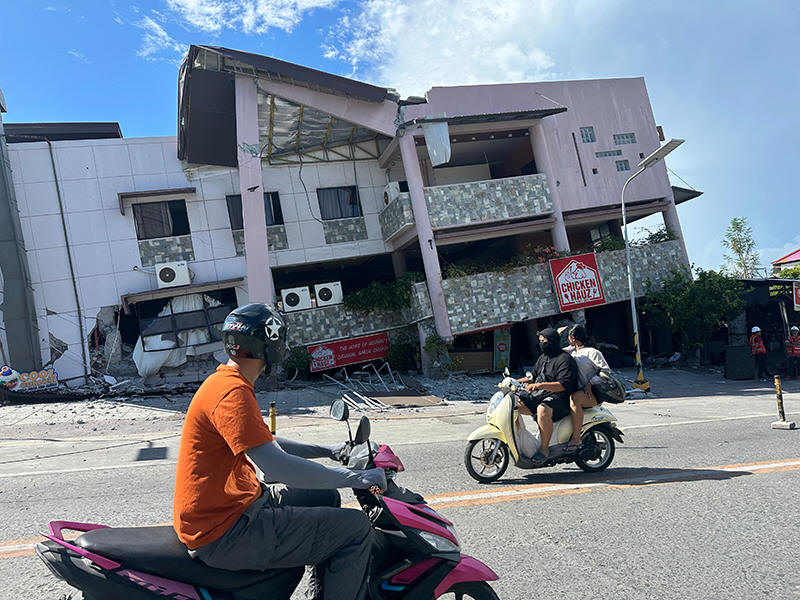
A few buildings collapsed and key infrastructure sustained quake damage
in the city of General Santos, and tsunami damage was reported in at
least one coastal village. Smaller waves were measured in Indonesia and
Palau and as far away as southern Japan.
“It’s a major earthquake," Teresito Bacolcol, the director of the
Philippine Institute of Volcanology and Seismology said, warning people
to seek advise before returning to damaged buildings and houses which
could collapse due to aftershocks.
“Our pickup truck suddenly jerked and I thought we had a flat tire,”
said Rod Sosmeña, regional director of the Office of Civil Defense, told
The Associated Press from the hard-hit port city of General Santos,
where he was traveling when the quake struck at 7:37 a.m.
“The shaking was very strong and people dashed out of houses into the
streets," Sosmeña said.
Another regional disaster-response official, Ednar Dayanghirang, told
The AP that he was able to “hardly stand and keep my balance when the
ground shook as I was leaving my house” in the southern port city of
Davao.

General Santos is a port city of more than 700,000 people that is a
regional hub for the tuna export industry and other commerce.
It was the strongest quake to strike the Philippines this year, and was
was centered at sea off Mindanao, the second most populous island in the
Philippines. According to Bacolcol, the quake occurred at a depth of 33
kilometers (20 miles), about 32 kilometers (20 miles) southwest of
Maasim town in Sarangani province.
Philippine President Ferdinand Marcos Jr. ordered the cancellation of
classes and directed disaster-response agencies to immediately get to
work in quake-hit provinces, saying “the national government is moving
and we will not leave Mindanao behind.”
The Pacific Tsunami Warning Center said the threat of a tsunami largely
passed about five hours after the quake. Philippine officials also
lifted a tsunami warning by mid-afternoon. Six shanties on stilts were
damaged in a coastal village in Zamboanga del Sur due to the quake and
taller waves, officials said.
Assessing damage and casualties
At least 19 people were killed, mostly in collapsed buildings and
landslides, while thousands of villagers were displaced, Office of Civil
Defense spokesperson Junie Castillo said without providing specific
details.
Among the dead were seven people in General Santos, where a few small
buildings, including a popular hamburger joint, collapsed or were
severely damaged, Sosmeña said.
The other deaths were caused by falling debris, a damaged mosque and a
landslide in the southern provinces of Sarangani, South Cotabato and
Davao Occidental and on Balut Island, Sosmeña and another reginal
disaster-response official, Ednar Dayanghirang, said.
Sosmeña said authorities were checking reports of some students being
trapped in a two-story school that collapsed in General Santos. He could
not immediately provide details but the national police said at least 12
people were missing in General Santos.
[to top of second column]
|
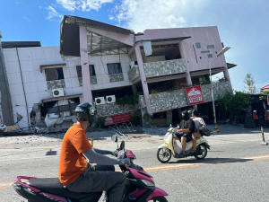
Residents pass by a collapsed structure after an earthquake in
General Santos, Philippines on Monday, June 8, 2026. (AP Photo)

The Bureau of Fire said without elaborating that it was involved in
search and rescue efforts in a damaged building and a warehouse in
General Santos.
Public schools had reopened nationwide Monday after the summer
vacation from April to May. Dayanghirang said more than 100 students
attending morning flag-raising ceremonies in his southern region
sustained bruises and some fainted in panic.
The international airport in General Santos was temporarily shut,
and 17 domestic flights were canceled, the Civil Aviation Authority
of the Philippines said.
The DZRH radio network in Manila reported that a small commercial
building where its provincial station was located partly collapsed
and staffers dashed to the ground floor without injuries. It wasn’t
clear if other people were trapped in the rubble of the four-story
office building. Debris also fell from other buildings, hitting
tricycle taxis parked below.
Tsunami waves near 3 feet measured
Waves of 1 meter (3 feet) were generally monitored in the provinces
of Sultan Kudarat and Sarangani. A 1.4-meter (4.6-foot) wave was
monitored at one time in the coastal area of Kiamba town in
Sarangani, Bacolcol said.
The quake was also felt in Malaysia's Sabah state on Borneo island.
Sabah is just a boat ride away from southern Philippines. An
83-centimeter (2.7-feet) tsunami was measured by a gauge off
Indonesia's Sulawesi island, and the PTWC said 30-centimer (1-foot)
waves were measured in Palau.
Waves up to 20 centimeters (7.8 inches) were detected on the remote
Japanese island of Chichijima and the central Japanese town of
Kushimoto, the Japan Meteorological Agency said.
The U.S. Geological Survey reported the depth of the original quake
at 55 kilometers (34 miles). Variations in measurements by different
agencies are common in the immediate aftermath of an earthquake.
Aftershocks as strong as 6.5 magnitude were recorded.
The Philippines, one of the world’s most disaster-prone countries,
is often hit by earthquakes and volcanic eruptions due to its
location on the Pacific “Ring of Fire,” an arc of seismic faults
around the ocean. The archipelago is also lashed by about 20
typhoons and tropical storms each year.
___
Associated Press journalists Edna Tarigan in Jakarta, Indonesia,
Eileen Ng in Kuala Lumpur, Malaysia, and Mari Yamaguchi in Tokyo
contributed to this report.
All contents © copyright 2026 Associated Press. All rights reserved
 |