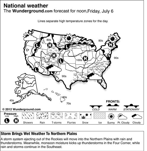
|
 Daytime temperatures will once again climb well into the 90s and lower to mid-100s during the afternoon, while heat index values range from 100 to 115 degrees. Expect a variety of
heat advisories, excessive heat watches and excessive heat warnings to remain in effect, especially across the Midwest. Residents are encouraged to take extra precautions while outside to reduce the risk of heat exhaustion and heatstroke. Daytime temperatures will once again climb well into the 90s and lower to mid-100s during the afternoon, while heat index values range from 100 to 115 degrees. Expect a variety of
heat advisories, excessive heat watches and excessive heat warnings to remain in effect, especially across the Midwest. Residents are encouraged to take extra precautions while outside to reduce the risk of heat exhaustion and heatstroke.
In the East, chances of showers and thunderstorms will continue across the Great Lakes and Ohio Valley as a cold front in the
upper Mississippi Valley moves into the upper Great Lakes and a second cold front drops across the
lower Great Lakes and Northeast. Expect cooler and more stable conditions in the Northeast with the passing of this cold front.
To the south, strong daytime heating and high instability will maintain chances of shower and thunderstorm development across the
eastern valleys, Mid-Atlantic and Southeast. Areas of the Ohio Valley through the
central Appalachians, the Tennessee Valley and the central Gulf Coast states are at slight risk of severe thunderstorm development with damaging wind gusts.
In the West, deep monsoon moisture will begin to really pick up across the Four Corners on Thursday. This moist flow will support isolated to scattered showers and chances of afternoon and evening thunderstorms in the Southwest, the
central Great Basin, and the central and southern Rockies. Frontal disturbances pushing across the
central Rockies will spread moisture and energy northeastward into the central and
northern Plains. This will translate into favorable conditions for clusters of showers and thunderstorms in parts of northeastern Wyoming, the Dakotas and Nebraska Thursday afternoon through Thursday night. Areas of the
northern Plains are at slight risk of severe thunderstorm development with damaging wind gusts and large hail from late Thursday afternoon through Thursday night.
Temperatures in the Lower 48 states Wednesday ranged from a morning low of 25 degrees at Stanley, Idaho, to a high of 106 degrees at Smyrna, Tenn.
|