 This forecast is for the counties of Knox, Stark, Peoria, Marshall,
Woodford, Fulton, Tazewell, McLean, Schuyler, Mason, Logan, DeWitt,
Piatt, Champaign, Vermilion, Cass, Menard, Scott, Morgan, Sangamon
and Macon, including the cities of Galesburg, Peoria, Bloomington,
Normal, Havana, Lincoln, Champaign, Urbana, Danville, Jacksonville,
Springfield and Decatur. This forecast is for the counties of Knox, Stark, Peoria, Marshall,
Woodford, Fulton, Tazewell, McLean, Schuyler, Mason, Logan, DeWitt,
Piatt, Champaign, Vermilion, Cass, Menard, Scott, Morgan, Sangamon
and Macon, including the cities of Galesburg, Peoria, Bloomington,
Normal, Havana, Lincoln, Champaign, Urbana, Danville, Jacksonville,
Springfield and Decatur.A storm system will produce a prolonged
period when precipitation may fall across central Illinois,
beginning Monday and lingering through Tuesday night. The most
widespread precipitation is expected to fall late Monday night and
through much of the day Tuesday.
Locations along and north of a Rushville-to-Bloomington line
should see predominantly snow, while areas farther south will see
rain or sleet mixing in at times. Warmer temperatures along and
south of the Interstate 70 corridor will support primarily rain
there.
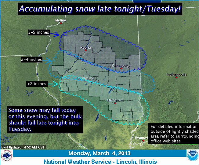
The potential for mixed precipitation will keep snowfall totals
lower than they might otherwise be, and surface temperatures above
freezing at times will cut snowfall totals as well. Current
indications are that a total of 3 to 5 inches of snow may fall along
and north of the Interstate 74 corridor. Areas a little farther
south, generally along a Fulton-Macon-Edgar County line, should see
2 to 4 inches of total snowfall. Accumulations will quickly taper
off farther south due to more rain mixing in and surface
temperatures staying above freezing for a longer period of time.
[to top of second column |

There is still some uncertainty with respect to the highest snowfall
totals with this system, although they should be highest over
northern Illinois. Continue to monitor later forecasts for updates
on this winter storm.

___
Graphical depiction:
http://www.crh.noaa.gov/wxstory.php?site=ilx
(Or see March 4 weather graphic below.)
For updates, check http://www.crh.noaa.gov/ilx/.
[Text from National Weather Service,
Lincoln office] |